
Are you looking for an essay on ‘Earthquakes’? Find paragraphs, long and short essays on ‘Earthquakes’ especially written for school and college students.
Essay on Earthquakes
Essay Contents:
- Essay on the Definition of Earthquakes
- Essay on the Types of Earthquakes
- Essay on Why do Earthquakes Happen
- Essay on Where do Earthquakes Happen?
- Essay on How are Earthquakes Studied?
- Essay on the Intensity of Earthquakes and their Scales
- Essay on the Focus of Earthquake
- Essay on Earthquake Hazards
1. Essay on the Definition of Earthquakes:
An earthquake in simple words is shaking of the earth. It is a natural event. It is caused due to the release of energy, which generates waves that travel in all directions.
An earthquake—a sudden motion of a part of the earth caused by an abrupt release of slowly accumulating stress—is a potent natural hazard. Although more infrequent than other types of natural disasters, an earthquake can cause devastation and loss of life on a scale far greater than any other individual natural hazard and is, therefore, generally regarded as the most destructive of the various forces of nature.
Earthquakes are shock waves that are transmitted from an epicenter, which can extend from the surface to 700 km beneath the Earth’s crust. Earthquakes generate a number of types of waves, viz., P-wave (compressional wave), S-wave (pro-pagational wave) and L-wave (long wave). The P-waves spread out from the centre of the earthquake. It consists of alternating compression and dilation.
The S-wave behaves very much like the propagation of a wave down a skipping rope that is being been shaken up and down. L-waves trapped between the surface of the earth and the crustal layers lower down, and spread slowly outwards from the epicenter along the surface of the globe.
Of all natural hazards, earthquakes generate the largest and longest range of associated phenomena that can be used to foreshadow the timing of the impending events.
Precursors of earthquakes group into the following five categories: land deformation, seismic activity, geomagnetic and geo-electric activity, ground water and natural phenomena (like catfish movement, aggressiveness of pigs, etc.). However, fool-proof prediction of large earthquakes is still not possible.
Seismic activity is well-monitored and documented throughout the world by a number of national and international recording networks.
Comprehensive listing of seismic events are held by several agencies such as the International Serological Centre (ISC) in Newbury, UK, and the National Earthquake Information Centre at the World Data Centre A in Boulder, Colorado, USA. Much research has also been conducted on areas of the world particularly prone to earthquakes with a view to improving predictive capabilities.
At least 35 countries face a high probability of being stuck by earthquakes. Although there are thousands of relatively small earthquakes around the world each year, it is those of magnitudes 6-8 on the Richter Scale which generally cause the greatest damage.
Each year on average, earthquakes kill 10,000 people on average and cause $US 400 million property damage. The Calcutta (India) earthquake of 11 October 1737 wiped out half the city killing 300,000 people.
Tokyo (Japan) earthquake of 1923 totally destroyed the largest city of Japan, having a death toll of 143,000 people.
Tangshan (China) earthquake in 1976, is another worst case claiming the death of 250,000 people.
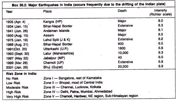
Seismic risk zone mapping was done through a variety of studies in many countries of Asia, Australia, and Alaska region. In India, risk zones (Zone I to V) were made depending on the geomorphic and other features of landforms. Appropriate land based activities and build structures were suggest as a mitigative measures.
2. Essay on the Types of Earthquakes:
There are many different types of earthquakes- tectonic, volcanic, collapse and explosion. The type of earthquake depends on the region of occurrence and the geological make-up of that region. The most common are tectonic earthquakes.
These occur when rocks in the earth’s crust break due to geological forces created by movement of tectonic plates. Another type, volcanic earthquakes, occurs in conjunction with volcanic activity. Collapse earthquakes are small earthquakes in underground caverns and mines, and explosion earthquakes result from the explosion of nuclear and chemical devices.
1. Tectonic Earthquake:
Earthquake that occurs when the earth’s crust breaks due to geological forces on rocks and adjoining plates that cause physical and chemical changes.
2. Volcanic Earthquakes:
Earthquakes that result from tectonic forces which occur in conjunction with volcanic activity.
3. Collapse Earthquakes:
Small earthquakes in underground caverns and mines that are caused by seismic waves produced from the explosion of rock on the surface.
4. Explosion Earthquakes:
Earthquakes which are the result of the detonation of nuclear and chemical devices.
3. Essay on Why do Earthquakes Happen?
Earthquakes are usually caused when rock underground suddenly breaks along a fault. This sudden release of energy causes the seismic waves that make the ground shake. When two blocks of rock or two plates are rubbing against each other, they stick a little. They don’t just slide smoothly; the rocks catch on each other. The rocks are still pushing against each other, but not moving.
After a while, the rocks break because of all the pressure that’s built up. When the rocks break, the earthquake occurs. During the earthquake and afterward, the plates or blocks of rock start moving, and they continue to move until they get stuck again. The spot underground where the rock breaks is called the focus of the earthquake. The place right above the focus (on top of the ground) is called the epicenter of the earthquake.
Try this little experiment:

1. Break a block of foam rubber in half.
2. Put the pieces on a smooth table.
3. Put the rough edges of the foam rubber pieces together.
4. While pushing the two pieces together lightly, push one piece away from you along the table top while pulling the other piece toward you. See how they stick?
5. Keep pushing and pulling smoothly. Soon a little bit of foam rubber along the crack (the fault) will break and the two pieces will suddenly slip past each other. That sudden breaking of the foam rubber is the earthquake. That’s just what happens along a strike-slip fault.
Earthquake-like seismic waves can also be caused by explosions underground. These explosions may be set off to break rock while making tunnels for roads, railroads, subways, or mines. These explosions, however, don’t cause very strong seismic waves. You may not even feel them.
Sometimes seismic waves occur when the roof or walls of a mine collapse. These can sometimes be felt by people near the mine. The largest underground explosions, from tests of nuclear warheads (bombs), can create seismic waves very much like large earthquakes. This fact has been exploited as a means to enforce the global nuclear test ban, because no nuclear warhead can be detonated on earth without producing such seismic waves.
4. Essay on Where do Earthquakes Happen?
Earthquakes occur all the time all over the world, both along plate edges and along faults.
Along Plate Edges:
Most earthquakes occur along the edge of the oceanic and continental plates. The earth’s crust (the outer layer of the planet) is made up of several pieces, called plates. The plates under the oceans are called oceanic plates and the rest are continental plates. The plates are moved around by the motion of a deeper part of the earth (the mantle) that lies underneath the crust.
These plates are always bumping into each other, pulling away from each other, or past each other. The plates usually move at about the same speed that your fingernails grow. Earthquakes usually occur where two plates are running into each other or sliding past each other.

Along Faults:
Earthquakes can also occur far from the edges of plates, along faults. Faults are cracks in the earth where sections of a plate (or two plates) are moving in different directions. Faults are caused by all that bumping and sliding the plates do. They are more common near the edges of the plates.
Types of Faults:
Normal faults are the cracks where one block of rock is sliding downward and away from another block of rock. These faults usually occur in areas where a plate is very slowly splitting apart or where two plates are pulling away from each other. A normal fault is defined by the hanging wall moving down relative to the footwall, which is moving up.

Reverse faults are cracks formed where one plate is pushing into another plate. They also occur where a plate is folding up because it’s being compressed by another plate pushing against it. At these faults, one block of rock is sliding underneath another block or one block is being pushed up over the other. A reverse fault is defined by the hanging wall moving up relative to the footwall, which is moving down.

Strike-slip faults are the cracks between two plates that are sliding past each other. You can find these kinds of faults in California. The San Andreas fault is a strike-slip fault. It’s the most famous California fault and has caused a lot of powerful earthquakes.

5. Essay on How are Earthquakes Studied?
Seismologists study earthquakes by going out and looking at the damage caused by the earthquakes and by using seismographs. A seismograph is an instrument that records the shaking of the earth’s surface caused by seismic waves. The term seismometer is also used to refer to the same device, and the two terms are often used interchangeably.
The First Seismograph:
The first seismograph was invented in 132 A.D. by the Chinese astronomer and mathematician Chang Heng. He called it an “earthquake weathercock.”
Each of the eight dragons had a bronze ball in its mouth. Whenever there was even a slight earth tremor, a mechanism inside the seismograph would open the mouth of one dragon. The bronze ball would fall into the open mouth of one of the toads, making enough noise to alert someone that an earthquake had just happened. Imperial watchman could tell which direction the earthquake came from by seeing which dragon’s mouth was empty.
In 136 A.D. a Chinese scientist named Choke updated this meter and called it a “seismoscope.” Columns of a viscous liquid were used in place of metal balls. The height to which the liquid was washed up the side of the vessel indicated the intensity and a line joining the points of maximum motion also denoted the direction of the tremor.

Modern Seismographs:
Most seismographs today are electronic, but a basic seismograph is made of a drum with paper on it, a bar or spring with a hinge at one or both ends, a weight, and a pen. The one end of the bar or spring is bolted to a pole or metal box that is bolted to the ground. The weight is put on the other end of the bar and the pen is stuck to the weight.
The drum with paper on it presses against the pen and turns constantly. When there is an earthquake, everything in the seismograph moves except the weight with the pen on it. As the drum and paper shake next to the pen, the pen makes squiggly lines on the paper, creating a record of the earthquake. This record made by the seismograph is called a seismogram.
By studying the seismogram, the seismologist can tell how far away the earthquake was and how strong it was. This record doesn’t tell the seismologist exactly where the epicenter was, just that the earthquake happened so many miles or kilometers away from that seismograph. To find the exact epicenter, you need to know what at least two other seismographs in other parts of the country or world recorded. We’ll get to that in a minute. First, you have to learn how to read a seismogram.

6. Essay on the Intensity of Earthquakes and their Scales:
Earthquake intensity is a measure of the effects of an earthquake at a particular place. It is determined from observations of the earthquake’s effects on people, structures and the earth’s surface. Among the many existing scales, the Modified Mercalli Intensity Scale of 12 degrees, symbolized as MM, is frequently used.
The intensity of an earthquake becomes weaker outward from the epicenter. However, various types of ground respond differently to earthquake vibrations. Buildings on filled ground are damaged more than structures built on solid rock even though both may be at the same distance from the epicenter.
The magnitude of a particular earthquake is a single number which does not vary from place to place. Magnitude is the total energy released by an earthquake at its focus.
Earthquakes of large magnitude are stronger and generally more destructive than those of small magnitude. The amount of destruction depends not only on the magnitude but on the kind of ground and types of buildings thereon, and on the location of the focus in relation to heavily populated areas.
Large earthquakes are preceded by many aftershocks, which may persist for days or weeks. The first shock is the most damaging. However, sometimes an aftershock may be even more powerful than the original shock.
The intensity of an earthquake is measured in terms of its geological effects and the overall damage it brings. There are two major scales in which earthquakes are measured.
These two scales are:
1. The Mercalli Scale and
2. The Richter Scale.
1. Mercalli Scale:
The Mercalli scale was introduced at the turn of the 20th century by the Italian seismologist Giuseppe Mercalli. This scale measures the intensity of shaking with numbers from I to XII. Intensity I on this scale is defined as an event felt by very few people, whereas intensity XII is assigned to a catastrophic event that causes total destruction. Events of intensities II to III are roughly equivalent to quakes of magnitude 3 to 4 on the Richter scale, and XI to XII on the Mercalli scale correspond with magnitudes 8 to 9 on the Richter scale.
(I) Hardly felt.
(II) Felt only by a few persons at rest, especially on upper floors of buildings.
(III) Can be felt by persons indoors, especially on upper floors of buildings. Many people do not recognize it as an earthquake.
(IV) Felt indoors by many, outdoors by few during the day. At night, some awakened. Dishes, windows, doors disturbed. Standing motor cars rocked noticeably.
(V) Felt by nearly everyone; many awakened. Some dishes, windows broken. Unstable objects overturned.
(VI) Felt by all.
(VII) Considerable damage in poorly built or badly designed structures.
(VIII) Damage slight in specially designed structures. Damage great in poorly built structures. Heavy furniture overturned.
(IX) Damage considerable in specially designed structures. Damage great in substantial buildings, with partial collapse. Buildings shifted off foundations.
(X) Many objects destroyed buildings collapse.
(XI) Few structures remain standing. Bridges destroyed. Rails bent greatly.
(XII) Total Damage.
2. Richter Scale:
The Richter scale was named after the American seismologist Charles Francis Richter. This scale measures the motion of the land surface 60 mi from the epicenter, or focus, of the earthquake. An estimated 800 quakes of magnitudes 5 to 6 occur worldwide each year. About 50,000 quakes of magnitudes 3 to 4 occur each year, and only about one of magnitude 8 to 9 each year.
Between to 0-4.3 on the Richter scale:
People at rest upstairs notice shaking.
Shaking felt indoors; hanging objects swing.
Between 4.3-4.8:
Sleeping people are awakened.
Dishes, doors and trees shake and rock.
Between 4.8-6.2:
Difficult to stand; people walk unsteadily.
Windows break; plaster, bricks, and tiles fall.
Between 6.2-7.3:
General panic.
Damage to foundations; buildings destroyed.
Water thrown out of river.
Between 7.3-8.9:
Total destruction; roads break up, rocks fall.
Large cracks appear in ground.

7. Essay on the Focus of Earthquake:
Earthquakes mainly occur when the different blocks or plates that makes up the Earth’s surface move relative to each other causing distortion in the rock. The distortion builds up very slowly, over tens or hundreds of years. Eventually the distortion is enough to cause the rock to break and move, releasing energy in the form of an earthquake.
The real place of origin of an earthquake is where the initial break propagates in the plates under the earth which releases energy along the fault. The earthquake originates from the entire fault – which may be 1000 km long. However, it is useful to refer to one part of the fault as the place of origin of an earthquake, and this is taken as the initial break. It is called the Focus or Hypocenter of the earthquake. This is usually below the Earth’s surface.

Most earthquake foci are within a few tens of kilometers of the surface. Earthquakes less than 70 km deep are classified as shallow-focus. Earthquakes with foci 70-300 km deep are classified as intermediate-focus and those below 300 km are deep-focus. Shallow-focus earthquakes occur more often than deeper ones; about 75% of the total energy released from earthquakes is from shallow- focus ones.
Unfortunately, the shallower an earthquake, the more damage it can produce at the surface; intermediate and deep-focus earthquakes are rarely destructive. No earthquakes are known to have occurred below about 700 km. at greater depths the rocks are very hot and under high pressure so they deform by flowing rather than breaking and faulting.
Focal Depth of Earth:
Focal depth of an earthquake is the distance from the surface of earth to the focus point of earthquake. The most obvious indication on a seismogram that a large earthquake has a deep focus is the small amplitude, or height, of the recorded surface waves and the uncomplicated character of the Primary and Secondary waves.
Although the surface-wave pattern does generally indicate that an earthquake is either shallow or may have some depth, the most accurate method of determining the focal depth of an earthquake is to read a depth phase recorded on the seismogram.
The focal depth can be calculated from measurements based on seismic wave phenomena. As with all wave phenomena in physics, these is an uncertainty in such measurements that grows with the wavelength so the focal depth of the source of these long-wavelength (low frequency) waves is difficult to determine exactly. Very strong earthquakes radiate a large fraction of their released energy in seismic waves with very long wavelengths and therefore a stronger earthquake involves the release of energy from a larger mass of rock.
Epicenter:
It is the point on the earth’s surface that is directly above the focus. Its the location on the surface of the Earth that is above the focal point of an earthquake. From this point the waves of the earthquake radiate outward like the ripples in a pond when a stone is thrown in.
Epicentral Distance:
During an earthquake, Seismic waves propagate spherically out from the hypocenter. Seismic shadowing occurs on the opposite side of the Earth from the earthquake epicenter because the liquid outer core refracts the longitudinal or compressional (P-waves) while it absorbs the transverse or shear waves (S-waves).
Outside of the seismic shadow zone both types of wave can be detected, but due to their different paths through the Earth, they arrive at different times. By measuring the time difference on any seismograph as well as the distance on a travel-time graph at which the P-wave and S-wave have the same separation, geologists can calculate the distance to the earthquake’s epicenter. This distance is called the epicentral distance, commonly measured in ° (degrees) and denoted as Δ (delta) in seismology.
Once epicentral distances have been calculated from at least three seismographic measuring stations, it is a simple matter to find out where the epicenter was located using trilateration.
Earthquake Energy:
The amplitude of a seismic signal is proportional to the energy (E) released in an earthquake. There is no consensus on the actual equation. This is based on the Richter magnitude but also depends on the frequency of the wave, distance from the source, etc., and is of the form log E = aM + b. The annual energy dissipation by this means is estimated to be more than 1011 watts, of which 75% is released in shallow earthquakes and 3% in deep.
Surprisingly, considering the forces that we see at the surface, not all the energy involved in an earthquake is transformed into ground motion; much of it is consumed by frictional heating and rock pulverization. An analysis of pulverized rock, or gouge, collected from the San Andreas Fault in California and from a rupture zone at 2 km depth in a South African gold mine contradicts the commonly held view that gouge surface energy is a negligible component of earthquake energy balance.
The analysis reveals unexpected diminutive particles in gouge samples, indicating that pulverization, not frictional heating, is the major consumer of earthquake energy at depth. This might explain the heat flow anomaly seen in the San Andreas fault system and perhaps some other long-standing puzzles in earthquake energetics.
Basic concepts of earthquake resistant houses and construction practices:
Step 1:
Design ground beams for earthquake-resistant housing. Join steel beams together by the feet and allow them to go outside the line of the building to decrease the chance of the structure overturning.
Step 2:
Build floors with a light material similar to the roof. Use plywood, chipboard or plain timber with joists bolted firmly to the floor for earthquake-resistant housing.
Step 3:
Ensure that buildings resist sideways pressure. Build the roof with a lightweight material. Brace the building diagonally to resist sideways loads of debris.
Step 4:
Construct wood-frame housing. Although it’s lightweight, wood provides a strong resistance to earthquakes. Tie wall wells to the house foundation when building and nail wood firmly to studs to increase the earthquake resistance of the structure. Use a shear wall construction with studs forming the wall’s shell and horizontal joists making up the floors and rafters supporting the roof.
Step 5:
Establish a large panel system for residences. Set up concrete panels vertically and horizontally to surround the rooms in an apartment building. These panels uphold the building’s structural integrity along with vertical and horizontal floor panels.
Step 6:
Use a modular building system. Stack ready-made boxes and connect them together. The walls that form resist shaking caused by earthquakes from both directions. Pipes as well as wall and floor finishes fit in an earthquake-resistant concrete box.
8. Essay on Earthquake Hazards:
Some movies show scenes with the ground suddenly opening up and people falling into fiery pits, but this just doesn’t happen in real life:
1. Ground Shaking:
The first main earthquake hazard (danger) is the effect of ground shaking. Buildings can be damaged by the shaking itself or by the ground beneath them settling to a different level than it was before the earthquake (subsidence).
Buildings can even sink into the ground if soil liquefaction occurs. Liquefaction is the mixing of sand or soil and groundwater (water underground) during the shaking of a moderate or strong earthquake. When the water and soil are mixed, the ground becomes very soft and acts similar to quicksand (daldal). If liquefaction occurs under a building, it may start to lean, tip over, or sink several feet.
The ground firms up again after the earthquake has past and the water has settled back down to its usual place deeper in the ground. Liquefaction is a hazard in areas that have groundwater near the surface and sandy soil. Buildings can also be damaged by strong surface waves making the ground heave and lurch. Any buildings in the path of these surface waves can lean or tip over from all the movement. The ground shaking may also cause landslides, mudslides, and avalanches on steeper hills or mountains, all of which can damage buildings and hurt people.
2. Ground Displacement:
The second main earthquake hazard is ground displacement (ground movement) along a fault. If a structure (a building, road, etc.) is built across a fault, the ground displacement during an earthquake could seriously damage or rip apart that structure.
3. Flooding:
The third main hazard is flooding. An earthquake can rupture (break) dams or levees along a river. The water from the river or the reservoir would then flood the area, damaging buildings and maybe sweeping away or drowning people.
Tsunamis and seiches can also cause a great deal of damage. A tsunami is what most people call a tidal wave, but it has nothing to do with the tides on the ocean. It is a huge wave caused by an earthquake under the ocean. Tsunamis can be tens of feet high when they hit the shore and can do enormous damage to the coastline. Seiches are like small tsunamis. They occur on lakes that are shaken by the earthquake and are usually only a few feet high, but they can still flood or knock down houses, and tip over trees.
4. Fire:
The fourth main earthquake hazard is fire. These fires can be started by broken gas lines and power lines, or tipped over wood or coal stoves. They can be a serious problem, especially if the water lines that feed the fire hydrants are broken, too. For example, after the Great San Francisco Earthquake in 1906, the city burned for three days.
Most of the city was destroyed and 250,000 people were left homeless. Most of the hazards to people come from man-made structures themselves and the shaking they receive from the earthquake. The real dangers to people are being crushed in a collapsing building, drowning in a flood caused by a broken dam or levee, getting buried under a landslide, or being burned in a fire.