
Here is a term paper on ‘Earthquakes’. Find paragraphs, long and short term papers on ‘Earthquakes’ especially written for school and college students.
Term Paper on Earthquakes
Term Paper # 1. Introduction to Earthquakes:
Stability of the crust of the Earth is an essential condition for the propagation of life on this planet. Broadly speaking, the earth’s crust has attained stability to a great extent. It is, however, a matter of common knowledge that some parts of the world do get shaken momentarily once a while.
Although minor shocks are recorded at most places quite frequently, we do read, and hear (and some might have even experienced) about major shocks that were quite destructive. These momentary shocks experienced by the earth at different locations and different times, are called as Earthquakes.
Technically, earthquakes may be defined as:
“Vibrations induced in the earth’s crust due to internal or external causes that virtually shake up a part of the crust and all the structures and living and non-living things existing on it”.
These vibrations often induce in the ground actual movements (acceleration) which are generally of short duration, rarely exceeding 1 minute. They are greatly variable in intensity, magnitude and direction.
Civilizations throughout the history have been gripped with fear of earthquakes because of their devastating effects. These are the strongest, quickest and most unexpected of natural calamities. The earliest documented earthquake in China in 1556 killed 830,000 people in a matter of minutes. Since then, a number of major earthquakes have visited Japan, Indonesia, Russia and adjoining states, Italy, India and many other parts of the world leaving behind trails of destruction and devastation.
In the twentieth century alone, hundreds of thousands of people were killed in different parts of the world due to earthquakes ‘in seconds’ in each case and much larger number crippled for life. The Gujarat earthquake of 26 January 2001 when the country was to celebrate its Republic day shook the psyche of the country killing and injuring more than one hundred thousand persons in a single day.
The study of earthquakes is of special significance for an engineering geologist and a civil engineer in that they are required to:
(i) Ascertain the factors that lead to earthquake tremors;
(ii) Predict the occurrence of an earthquake, and
(iii) Design and provide such structures that will afford protection during an earthquake for the human life.
Term Paper # 2. Classification of Earthquakes:
Earthquakes are classified on a number of bases such as
(a) Depth of focus,
(b) The intensity and the magnitude
(c) The cause of origin.
(a) Depth of Focus as Basis:
Three classes of earthquakes are recognized on the basis of depth of focus – shallow, intermediate and deep seated.
In the shallow earthquakes, depth of focus lies anywhere upto 60 km below the surface. A great majority of the earthquakes in the past had been of this type.
The intermediate earthquakes originate between 60 and 300 km below the surface. These are rare in occurrence but their effects are felt over large areas.
The deep seated earthquakes originate between 300 and 700 km, and are very rare phenomena.
(b) Magnitude as Basis:
It is customary to mention an earthquake by its magnitude on Richter scale, such as 7.5, 7.8, and 8.2 so on.
Sometimes earthquakes are grouped into five classes on the basis of magnitude as follows:
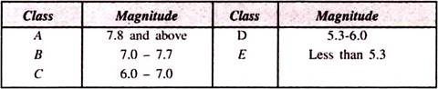
Earthquakes of class A are highly destructive whereas those of class E are not of any significance in relation to engineering structures.
(c) Cause of Origin as Basis:
Two broad classes of earthquakes distinguished on this basis are:
(i) Tectonic earthquakes, which are caused due to faulting or relative displacements of blocks of the crust of the earth along rupture planes. Most commonly, the major earthquakes are of tectonic origin.
(ii) Non-Tectonic earthquakes, which owe their origin to causes distinctly different from faulting such as volcanic eruptions, atomic explosions or due to landslides and subsidence.
Term Paper # 3. Causes of Earthquakes:
The causes that lead to origin and propagation of shock waves through the ground during an earthquake may be non-tectonic or tectonic in character. Among the non-tectonic causes, vibrations induced due to volcanic eruptions, atomic explosions and collapse of ground need no detailed discussion as these could be easily observed and confirmed.
Thus it is a well-established fact that areas situated around active volcanoes actually shudder during the forceful eruption of lava from the volcanoes. In fact, in some cases, the volcanic eruption itself may be of an explosive, blasting nature. Huge quantities of lava are thrown out suddenly under great pressure and with a big bang, causing tremors all around. Volcanic earthquakes, as these are called, are rarely felt outside the regions of active volcanoes.
The collapse earthquakes are invariably of a local nature, and rare occurrence. These are caused when a portion of ground collapses suddenly because of removal of support from below due to natural processes of rock wastage. Similarly quite severe local tremors may be caused by huge landslides or rock bursts, especially in hilly terrain.
The Tectonic Earthquakes:
The tectonic earthquakes are the most common and often the most destructive events. Their exact cause of origin is as yet not fully established. It is broadly agreed that these are caused due to displacement of blocks along fractures called faults, and that the focus of an earthquake indicates the depth at which this displacement originates.
Many theories have been put forward from time to time to explain rupture and consequent generation of earthquake vibrations. The Elastic Rebound Theory propounded originally by H.F. Reid in 1906 is, at present, widely acclaimed as a satisfactory explanation. It was proposed by him, on the basis of elaborate studies of San Francisco Earthquake of 1906 that it was related to displacement along the San Andres fault.
According to this theory, rocks are believed to behave as elastic masses towards operating stresses. When these are stressed, the rocks respond by bending as a first reaction. When the stressing conditions continue, the elastic limit may be reached and rupture may develop associated with displacement of the blocks along the plane/surface of rupture.
The plane of rupture and displacement is called the fault plane and faulting respectively. The cardinal point of elastic rebound theory is that displacement is associated with a rebound or readjustment of curvature developed due to bending during stressing. At the time of this process of rebound, most of the elastic energy stored during stressing is released at the place of displacement (focus) in the form of energy waves, or the seismic waves.
In the most simplified form, the earthquake mechanism may be explained as occurring in three phases in accordance with elastic rebound theory:
First, the preparatory process, in which a non-hydrostatic stress field is created in a certain region around a fault; the duration of the preparatory phase is to ultimately define the size of the actual earthquake. A number of ‘foreshocks’ are often recorded during this phase.
Second, the rupture phase, during which rupture takes place along the fault and all or part of the stored elastic energy is released as seismic waves and also transformed into heat or potential energy. Main shock is the characteristic of this phase.
Third, the post failure adjustment, during which the medium is restored to a state of equilibrium involving series of “after-shocks” which are simply manifestation of release of residual strain from the rocks. These after-shocks are often recorded for many months from the time of occurrence of the main shock. In fact the relationship between the behaviour of ground during fore shock and main shock, and also between main shock and after shock as reflected in seismic records presents interesting clues about the mechanism of earthquakes.
Plate Tectonics and Earthquakes:
In recent times, the concept of plate tectonics has been made use of in explaining the origin of tectonic earthquakes. Already exhaustive data has been collected to show that earthquakes occur along the boundaries of plates moving apast each other.
It has also been shown that whereas shallow earthquakes form belts (in terms of occurrence) along boundaries of plates moving apast each other, the deep-focus and intermediate earthquakes have a tendency to occur in few locations or ‘nests’ only.
The tectonism involving earthquakes is related to those boundaries, which are stressed and where stress is released by way of thrust faulting, block faulting or transcurrent faulting. The inner regions of plates are by and large free from tectonic earthquakes.
These are the plate boundaries where the lithospheric plates are either diverging or converging or moving apast each other. The diverging boundaries commonly result in rise of molten material from the interior of the earth creating the suboceanic ridges and adding to the crust. Vulcanism in itself is often violent enough to cause the shaking in the surrounding areas.
In the case of converging boundaries, earthquakes will be caused due to subduction of one plate under another plate and even during colliding of two continental plates, face to face, from opposite directions. Since the plate movements at the boundaries are very slow, stresses go on building up in the rocks of the immediate neighbourhood till the limits are reached. Ruptures (faulting) accompanied by displacement and rebounding of the displaced edges takes place with release of the stored elastic energy in all directions as seismic waves.
The distribution pattern of earthquakes in the past along the plate boundaries is considered strong enough an evidence in support of plate-tectonics-earthquake relationship in general.
Reservoir Associated Earthquakes:
During the second half of the twentieth century, a new class of earthquakes associated with impounding of water in artificially created reservoirs has come to be recognized in itself. These are called the reservoir associated earthquakes. It is a fact that no change in seismicity has been observed for years in the case of scores of major reservoirs created in different regions of the world.
However, the evidence of earthquakes visiting suddenly in certain hitherto established aseismic regions with filling of water in the reservoirs created in some areas is also conclusive. The Koyna earthquake of India (10th December, 1967) which resulted in the death of 200 persons, injured more than 1500 people and was felt for more than 1500 km occurred in an area that stood classified as most stable and aseismic, the Peninsular part of India.
Seismic shocks started occurring in this region right after impounding of water started in the Koyna reservoir created behind Koyna dam in Maharashtra State culminating on the night of 10th December, 1967 in a major earthquake that measured magnitude M 7.5 at the epicenter.
Seismic shocks associated with filling of water in reservoirs have also been recorded and studied extensively from many other parts of the world. Prominent areas among the classic examples of such reservoir – associated seismic activity are – Lake Kariba in Zambia, Lake Kremsata in Greece and Lake Meed in U.S.A., Vajont Dam, Italy, and Korube Dam, Japan.
Cause:
There is no agreement on the presumption that mere ‘filling’ of water and the resulting additional load on the strata below the reservoir could be the sole cause of tremors. In that case shocks should have been recorded around all the major reservoirs of the world. Facts do not corroborate this.
However, it is agreed that in certain regions, which are already critically stressed, earthquakes could be caused during and after filling of water in the reservoir due to any one or both of the following reasons:
(i) Sagging Effect of the Load:
Since the rocks at the base of a basin are to bear additional load due to impounded water, these adjust to the new loads by bending or sagging thereby initiating stress – redistribution in their regime. This readjustment may be sufficient in certain already critically balanced cases to trigger seismic shocks. In the normal case, however, the additional stresses may be simply absorbed by the enormous stable rock regime below. Association of increased seismicity with peak filling is cited as an agreement in favour of additional – load hypothesis.
(ii) Increased Pore Pressure:
It is believed that when water is stored in a reservoir, the pore pressure in the basin rocks is increased considerably. Such an increase (in pore pressure) has an adverse effect on the shearing strength of the basin rocks, which may lead to their failure and slippage, and the associated increase in seismicity.
It has been observed in many cases that seismicity associated with reservoir filling shows some different characteristics in terms of frequency-magnitude, fore shock, main shock and after-shock relationships, as compared to normal tectonic earthquakes.
Term Paper # 4. Effects of Earthquakes:
Appearance of an earthquake of appreciable magnitude is generally accompanied by a train of effects some of which may be highly destructive in nature. The character of the effects varies with the severity of the earthquake as well as distance of the place under consideration from the epicenter of that particular earthquake.
RICHTER classifies the effects of earthquakes into two main categories:
i. Primary effects and
ii. Secondary effects.
i. Primary Effects:
These include all such effects that are directly related to the cause of origin of an earthquake. The tectonic earthquakes are often responsible for producing many important changes in the geological structure of an area – creation of slopes or scarps, fissures, warping of strata, emergence or subsidence of coastlines; changes in the courses of streams; origin of new springs and creation of sand dykes in which saturated layers of sand may be forced up into existing cracks and crevices.
ii. Secondary Effects:
All those effects which are related to passage of seismic waves and associated shaking motion of the ground during an earthquake are broadly grouped as secondary effects. The distinction is, of course, subtle and more of theoretical rather than of practical importance. The secondary effects are observed on construction of all types.
Many landslides are triggered mainly due to shaking vibrations rather than actual rupture. Due to these vibrations buildings, bridges, dams, poles and posts and fences etc. may be slightly or heavily damaged. Loose objects may be overturned or thrown away. Telegraphic and electric cables and water pipes may get broken.
Huge waves may be caused in the sea waters; these are called Tsunamis and may be as high as 20 m or more. Trees may get uprooted and their trunks and branches may get twisted and broken. Animals of all types are seen to react differently and abnormally during an earthquake. Thus, horses may start snorting and bolting, dogs start barking and whining and all types of cattle suddenly tend to stampede.
Even birds offer strange reactions. Human reaction towards the earthquakes is almost typical – non-descript nervousness during feeble shocks; fear, panic and tendency to rush out for safety in the milder shocks; utter confusion amounting to going suddenly blank in the severe shocks.
The effects on standing structures as buildings, towers, tunnels, dams and reservoirs vary from simple disturbance to complete destruction creating havoc. Loss of life and damage to property are two standard measures for describing the effects of an earthquake.
Term Paper # 5. Recording of an Earthquake:
An earthquake is always a complex geological phenomenon.
Its effects mentioned above, may seem simple in description but in actual practice they may be the result of combined action of a variety of factors:
(i) Release of elastic energy
(ii) Propagation of the seismic waves through the ground and
(iii) Acceleration of the ground.
Recording of any one or more of these factors in quantitative terms during a very brief spell, generally less than a minute is a highly complicated job requiring technological sophistication of the highest order. The interpretation of the (seismic) records so obtained is a field of specialization. We give below only an outline of the principles involved and design of some main instruments used for recording earthquakes.
Seismographs:
Since an earthquake generates waves and these waves disturb the ground through which they travel according to their characteristic nature, an earthquake could be said as having been recorded if the passage of these waves is actually recorded. The instrument designed to record earth motion set up by seismic waves is called a seismograph.
The actual record of motion produced by a seismograph is called a seismogram (analogy – telegraph records telegram). Since during an earthquake ground is accelerated in both horizontal and vertical directions, a seismograph may be designed for recording either the horizontal or the vertical component of ground motion.
Presently, these are pendulum type seismographs which are installed and used for recording the earthquakes in many important locations (the seismographic stations) throughout the world. The essential part of such a seismograph is a pendulum which swings in a fixed plane.
In normal times, the pendulum remains at rest. During an earthquake, its oscillations or deflections are recorded, with desired magnifications by means of properly designed devices working on the principles of mechanical levers, light beams, variable transformers or magnetic tapes, etc.
In the simplest case, a seismograph consists of a pendulum (heavy mass) attached to a delicate boom suspended with a vertical axis through a tie wire. In front of the pendulum is placed a drum capable of rotating at a fixed speed and having a threaded axis of rotation so that it can advance during the rotation. A paper is wrapped over the drum. The boom is provided with a recording device, such as a pointed pencil, levered to it. The drum is provided with a clock and a time-marking device.
The assembly is normally at rest except the clock but the moment a shock is received by the seismograph, the boom starts oscillating, the drum starts rotating and the time-marker records the time of disturbance on the paper. As the boom oscillates, the pencil point makes wavy outlines on the paper over the advancing drum.
The amplitude and length of the wavy outlines so traced form the chief elements of the seismogram of the particular earthquake. In the delicate and accurate type of seismographs, the records are obtained on photographic paper using thin beams of light. These require recording at seismographic stations in dark-room conditions. This type of seismograph records only horizontal component of vibrations.
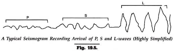
A highly simplified seismogram is shown in Fig. 19.5. The first wave-like forms are due to P- waves, which are followed, after a small interval of time, by forms due to S-waves. Last of all are recoded high-amplitude surface waves of large periods.
The records obtained by seismographs are highly magnified, the gains ranging from 100 to 2,00,000 times.
The sensitivity of a seismograph is related primarily to design period. To, of the pendulum. Based on this, a seismograph may record ground acceleration, ground velocity or mere ground displacement during an earthquake.
Thus:
(a) When To (of the pendulum) is shorter compared to the period of ground motion, the deflections induced would be broadly proportional to the ground acceleration. Such an instrument is called an accelerometer and the records produced by it as accelerograms which are more often used by the design engineers in the study of response of building to earthquake shocks.
(b) When To is very long compared to the period of ground motion, the deflection would be approximately proportional to the displacement of the ground. These are called ‘displacement type’ seismographs.
(c) If the period To is of the same order as that of ground motion, the instrument would record deflections intermediate between displacement and acceleration, or in other words, signal proportional to ground velocity. These are often called velocity type seismographs.
Determination of Magnitude and Energy:
With every earthquake, enormous amount of energy is released. Though all of this energy never reaches the recording station, it could be linked with ground acceleration.
An equation giving such a relationship is:
√E = C. a/h (D2 + h2)
where E is energy released in ergs, a is ground acceleration, h is the depth of focus, and D is distance of place under consideration from the epicenter and C is a constant. The ground acceleration in the above equation is obtained with the help of accelerographs.
Different Energy-Magnitude relationships have been proposed and used by different workers, such as:
log 10E = 4.4 + 2.14M – 0.054M2 …(1)
log 10E = 1.5 M + 11.4 …(2)
log 10E = 1.7 M + 10.00 …(3)
The ‘M’ used in these relationships refers to surface wave magnitude. Tremendous energy, measured in millions of ergs, is released during strong earthquakes.
An idea about the energy released during an earthquake could be made from following observations:
The Taskent earthquake of 1966 is believed to have liberated 8 million kilowatt-hours of energy. The energy released during the 1970 Daghestan earthquake was about 100 times greater than this or 800 million kw-hours. Similarly, the estimates of energy released during the 1960 Chilean earthquake or 1964 Alaska earthquakes are put at many hundred folds from the above values.
Travel-Time Records:
There is a marked difference in the velocities of three types of seismic waves. From the seismographic records these differences can be calculated for each earthquake. The data so obtained forms the basis of travel time curves which could be very useful for assaying various seismic parameters such as location of epicenter and focus of that particular earthquake.
The travel-time record shown in Fig. 19.6 is only a simplified example. In this, the distance from the epicenter is plotted on x-axis and the time taken by the waves to reach various stations on y-axis. Compilation of such records depends upon availability of exact time details at which signals from the same earthquake shock had arrived at those stations. From such a record, the distance of the epicenter and time of origin can be calculated.

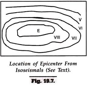
Location of Epicenter:
There are two ways to locate the epicenter of an earthquake – from the isoseismals and from S-P travel time curves. In the first method, which is rather approximate, epicenter is located at the place lying in the middle of the highest Isoseismal (Fig. 19.7).
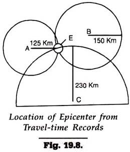
On the basis of S-P travel time curves, the difference between the arrival time of P-waves and S-waves, called S-P interval, is indicative of the distance (and not direction) between the place of origin and the recording station. Standard tables for distances equivalent to various S-P intervals have been prepared and are available for computations.
In other words the S-P intervals being known at a place, the distance of the epicenter from that place is broadly established but direction is not indicated – it could be anywhere along a circle drawn with that distance as radius. The job of locating the epicenter by this method requires such distances (based on S-P interval) from at least three properly located seismographic stations that have recorded the same earthquake.
With these stations as centers, and the S-P interval time distance as the radii and a convenient scale, three circles are drawn on a globe. If these stations are properly located, these circles may intersect at a point. That point is the place which is the epicenter of the particular earthquake.
For example, the S-P intervals recorded at three stations A, B and C, were 14 sec, 18 sec and 24 sec respectively. The corresponding epicentral distances for these stations are, say, 124 km, 144 km and 233 km. With A, B and C as centres, and the respective distances as radii, circles drawn on the globe intersect at E. This is approximately, the epicenter for that particular earthquake.
It may be mentioned here that it is seldom possible to determine the exact location of the epicenter. In the case of large earthquakes epicentral error may be of the order of many kilometers whereas in the case of local earthquakes, it may fall within a range of 5-100 km.
Same can be said about magnitude determinations. In the recent years, there have been persistent efforts to interlink space technology and seismology. There are great expectations in the sphere of seismic data collection and processing for which the interested readers should remain in touch with latest publications on the subject.
Term Paper # 6. Distribution of Earthquakes:
A study of occurrence of earthquakes in the past reveals at once a striking fact that earthquakes are very common features in some regions of the world whereas certain other parts have remained virtually stable since time immemorial.
Broadly speaking, shocks of the past had been largely confined to only two large geographical belts – (a) The Circum-Pacific Belt and (b) The Mediterranean Belt.
(a) The Circum-Pacific Belt forms a ring closing North America, most of Asia and Europe and accounts for more than 75.6% of world seismicity.
(b) The Mediterranean Belt also called the Alpide-Asiatic belt accounts for 22.1% of the world seismicity and includes areas of India, Arabia, Africa, South America and Australia.
The distribution pattern of past earthquakes shows that within these geographical belts, most of the earthquakes, more than 50 percent, occurred in the youthful mountain-system-areas of the world such as Andes, Himalayas and Coast Ranges of the United States. Similarly, a great number of earthquakes, about 40 percent, were located along the borders of continents steeply inclined towards oceans.
Term Paper # 7. Earthquake Problems in India:
A brief study of the geological history of India would reveal that a great part of this country has remained unstable and experienced some of the devastating earthquakes. At the same time some other parts have remained stable since ancient times yielding no records of earthquakes of any importance.
It is possible to divide India on seismic basis into following zones:
(a) Zone of Maximum Intensity:
This comprises the northernmost region extending east to west, all along and inclusive of the chain of Himalayas. Geographically this zone covers Assam, all the north-eastern states, northern Bihar, upper strips of Uttar Pradesh, Uttaranchal, Delhi, Haryana, Punjab, full regions of Himachal Pradesh and Jammu and Kashmir including Leh, Ladakh. Earthquake frequency and intensity as also magnitude of earthquakes recorded during past hundred years in these areas have always been highly damaging involving invariably considerable loss to life.
(b) Zone of Intermediate Intensity:
This covers the regions of Indo-Gangetic basin and bears the records of moderate earthquake intensity, ranging between VI and VIII in MM scale. Geographically this zone includes southern flat lands of Haryana, Punjab, Uttar Pradesh, Rajasthan, Madhya Pradesh, Bihar, Bengal, Orissa, northern parts of Gujarat and Maharashtra. Records show occurrence of few earthquakes of mild intensity and generally of low damage magnitude.
(c) Zone of Minimum Intensity:
The triangular part of India surrounded on the sides by Arabian Sea, Bay of Bengal and the Indian Ocean, has been considered a stable land since times immemorial, with respect to earthquake incidence. The only exception that created a sort of seismic puzzle, was the Koyna Earthquake of December 10-11, 1967, that occurred in the uppermost part of Peninsular India and caused considerable loss of life and property. However, researchers have proved that the Koyna earthquake could be considered an example of seismic activity triggered by reservoir filling (beyond Koyna dam) rather than a truly tectonic earthquake.
The above classification makes it evident that every care is required to introduce additional lateral stiffness in the design of new structures to be situated in the areas falling in the first two zones, more particularly in the northern Himalayan belt of the country. During the last four decades much attention has been paid in this direction and many eminent scientists and engineers have been busy in evolving well defined codes for quake-resistant construction.
Based on these studies and on the experience of countries facing the same problem, some general precautions are always suggested to be taken in the new construction in seismic regions. Designers for construction of buildings, dams, tunnels, factories and plants, power stations, storage tanks etc. in these regions are required to take lateral seismic loads into consideration as per the recommended coefficient values which stand at 0.1 to 0.15 for the zone of the maximum seismic intensity, 0.05 for the zone of intermediate intensity and 0.01 for the zone of maximum intensity.
Indian Earthquakes:
Areas lying in and along the Himalayas starting in the north western part of Kashmir and extending right through Kashmir, Punjab, Uttar Pradesh, Uttaranchal, Nepal and Assam Himalayas have experienced not less than 100 earthquakes during the past two hundred years or so of the recorded history.
Some of these earthquakes have been so devastating that their effects could be still observed ingrained in the body of the earth (in the form of displacements) and in the memories of people or their generations. Of these, the most disastrous were of Assam (1897), Kangra (1905) and Bihar (1934) recorded in the first half of the twentieth century and those of Bihar (1960), Koyna (1967) Maharashtra, and, of Uttrakashi, Uttar Pradesh (1992), in the later half of the twentieth century.
In the Assam earthquake of 12th June, 1897 severe shocks were felt over an area of 28,00,000 square kilometers. Shillong was worst effected region. The earthquake killed 1500 injuring another 4000 and resulted not only in destruction of standing structures but also in rupture of ground, dislocation of drainage system, initiation of massive slides and eruption of ground water at numerous places. The earthquake measured M = 8.5 on Richter scale.
An earthquake of similar intensity rocked Assam again on August 15, 1950 measuring 8.7 Richter scale and causing 1526 deaths. Similarly, the Kangra earthquake of 1905, measuring 8.6 on the Richter scale killed more than twenty thousand, people in a matter of few minutes. In the Bihar earthquake of January 15, 1934, some 12000 lives are believed to have perished. The earthquake measured M = 8.4 and originated at a depth of 20-30 km. It shook most of N. Bihar and adjoining areas of Nepal to ruins.
The Gujarat Earthquake of India that occurred on the morning of 26 January 2001 (recorded exactly at 3.16.40) killed at least 20,000 people and injured another 1,66,836. The earthquake had a magnitude of 7.7 in the Richter scale. It had devastating effects on at least more than two hundred thousand buildings of which nearly 35,000 were completely razed to the ground and 1.5 lakh damaged heavily.
All other civil engineering structures like roads, bridges, towers, railway lines etc. in the districts of Bhuj, Rajkot and Ahemdabad were badly damaged. Seismologists attributed the cause of this earthquake to the stresses developing due to slow northward pushing of Indian Plate against the Euroasean Plate. It may be mentioned here that these plates are still in the process of opposing movements and hence dangers of similar shocks in the future in the areas lying between the two plates cannot be ruled out at all.
Term Paper # 8. The Pakistan Earthquake of 2005:
A GREAT earthquake of magnitude 7.6 shook many parts of Western Pakistan on 8th October 2005 at 8.50.40 (local time). Its epicentre was located at Muzaffarabad, a town of Kashmir under Pakistan occupation, at 34.493°N and 73.629°E. The focus of the earthquake is believed to lie at Balakot which is 105 km NNE from Islamabad, the capital town of Pakistan.
Preliminary studies revealed that the number of fatalities exceeded 86000, perhaps the largest recorded during earthquakes in Indian subcontinent in past two hundred years. More than 85 percent of concrete frames and masonry in Balakot were totally destroyed. Further this earthquake was widely felt and created panic in many northern states of India as well like Jammu and Kashmir (Uri, Kupwara, Hindwara), Punjab, Himachal Pradesh and Delhi.
A total number of 1338 people lost their lives in Jammu & Kashmir where about 39000 buildings were fully damaged and another 71000 were partially damaged. The earthquake losses received worldwide attention and many countries sent liberal relief to the quake victims.
The most important aspect of this earthquake was spread of intensities over a long reach, from X (Rossi Forrel Scale) near the epicentre to as low as III beyond 100 km.
As regards the origin of this earthquake, geologists believe it to have happened due to a reverse fault which was just not more than 2 km below the surface at Balakot (epicentre). A series of slumps (slides) have developed at Balakot indicating the disturbance below.
The inferred reverse fault is explained as related to Indus-Kohistan Seismic zone which is believed to be a potential plate boundary in the Himalayan system.
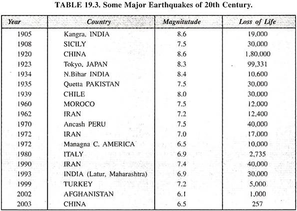
Term Paper # 9. World Seismicity:
Earthquakes have killed many hundred thousands of people in matters of minutes during past one hundred years. The destruction has been mostly confined to countries surrounding the Pacific Ocean and also a well-defined Alpide-Asian belt. Some of the worst earthquakes of twentieth century are mentioned below. The number of earthquakes visiting the world during the period runs in many hundreds. Hence the examples are only illustrative.
Term Paper # 10. Frequency of Earthquakes:
Results of a study of the literature and records of earthquakes since the year 1900 made by U.S. Geological Survey shows that about thousand earthquakes of magnitude between 2-3 shake our earth almost every day. The frequency (averaged on per year basis) of earthquakes presents a revealing reading as shown in table 19.4.
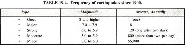
These figures are quite indicative of the inherent instability of the earth with which man has to deal persistently for ensuring his safe existence. These data also show the relevance and significance of the subject of aseismic designing and construction for a professional civil engineer, architect, and a town planner.