
Read this essay to learn about Earthquakes. After reading this essay you will learn about:- 1. Introduction to Earthquake 2. Geographical Occurrence of Earthquakes 3. Forms 4. Frequency 5. Associated Phenomena 6. Other Sources of Seismic Vibrations 7. Depth of Origin of Natural Earthquakes 8. Intensity of Earthquakes 9. Hazards 10. Prevention of Damage and Others.
Contents:
- Essay on the Introduction to Earthquake
- Essay on the Geographical Occurrence of Earthquakes
- Essay on the Forms of Earthquake
- Essay on the Frequency of Earthquake Occurrence
- Essay on the Associated Phenomena with Earthquake
- Essay on the Other Sources of Seismic Vibrations
- Essay on the Depth of Origin of Natural Earthquakes
- Essay on the Intensity of Earthquakes
- Essay on the Earthquake Hazards
- Essay on the Prevention of Damage-Earthquake Resisting Structures
- Essay on the Seismic Prospecting of Earthquakes
- Essay on the Review of Structure of the Earth
- Essay on the Instruments for Measuring the Size of Earthquake
- Essay on the Earthquake Waves Near Epicenter
Essay # 1. Introduction to Earthquake:
Earthquakes are tremors or vibrations from the passage of a series of vibratory waves through the rocks of the earth. Many small quakes are vibrations induced artificially by heavy street traffic, railway trains or by similar disturbances. Explosions too cause artificial earthquakes.
In general man-made earthquakes are felt over very limited areas only. In contrast, a natural earthquake is a vibration felt or measured at the earth’s surface by seismic or shock waves. These waves are created as rocks rupture under stress or friction below the surface of the earth resulting in the release of energy. Most often earthquakes are caused by slippage along a fault in the earth’s crust.
Some of the greater shocks may be perceptible over areas over millions of square kilometres. Other natural quakes may be localized within areas of a few square kilometres.
Natural earthquakes are among the most destructive of natural phenomena and are even more terrifying and destructive than the volcanic eruptions. Though natural quakes are due to a variety of causes, two principal genetic classes are recognized, viz. volcanic earthquakes and tectonic earthquakes.
i. Volcanic Earthquakes:
Shocks resulting from explosions incident to a volcanic eruption or from violent subterranean lava moments are called volcanic earthquakes. These quakes may be violent and locally destructive and are likely to be felt over very limited areas.
ii. Tectonic Earthquakes:
These earthquakes are caused due to sudden dislocations of large blocks of rock. When rocks are subjected to high stresses beyond their elastic limit, sudden relief by breaking or faulting allows the rock masses on either side of the break to rebound elastically to positions wholly or partially relieving the strain.
Fig. 16.1 shows a folded rock under highly stressed condition breaking along a fault plane so that the separated rock units rebound to reach a strain-free state. A huge amount of energy is released generating the earthquake waves, causing sufficient ground movement producing surface damage. Ground movements may be a few centimetres but the sudden motions of even such small extents can be catastrophic to buildings and other man-made structures.

Earthquake occurrences in Kashmir, Koyana, Jabalpur, Latur etc. during recent years indicate that no part of the earth is immune to seismic activity. The pacific ring of fire, the Alpine-Mediterranean-Trans Asiatic belt, mid-oceanic ridges in the Atlantic, Pacific and the Indian ocean, and the rift zones of the eastern Africa as well as east-central Siberia are the most vulnerable parts of the world.
Two-third of our country lies in the seismic region of moderate to severe intensity. The peninsular India has been unknown for severe earthquakes, but the koyana, Jabalpur and Latur earthquakes have complicated the problem.
Fracturing of rocks and consequent release of energy- by rapid motion, volcanicity and faulting, initiation of new faults or repeated movements of new faults or repeated movements of existing ones are primarily responsible for seismicity.
The association of seismic activity with faults was well established by 1916 California earthquake, when the SAF (San Andreas Fault) moved over a linear distance of about 430 km. The elastic rebound theory explaining the origin of earthquake is based on faulting.
Other factors, which may be responsible for the earthquakes, have been so far neglected. These are bombing, volcanic eruptions, rock falls from cliffs and rubbing together of two uneven surfaces in landscape and avalanche and submarine slumming of sediments.
However, the factors which are still being ignored are the nuclear test explosions, environmental degradation and man’s continuous interference with nature in the form of huge water dams, countless tunnels and under ground structured extension of metro railways.
Several studies have indicated that earthquakes lubricate themselves at an early stage and are therefore, able to spread more rapidly. The earthquake that hit Muzzafarbad in the Pakistan occupied Kashmir on October 8, 2005 is the biggest so far in the region (7.6 Richter scale). It is a warning for India and Pakistan to remain vigilant in the coming years.
India can be divided broadly into four seismic zones- zone-II to zone V. North-eastern areas, parts of Jammu and Kashmir, Himachal Pradesh, Uttranchal, Rann of Kutch and north Bihar fall in zone V with highest seismic intensity. The seasonal highest seismically active zone IV has the remaining parts of Jammu and Kashmir, parts of Punjab, U.P, H.P and Delhi.
Seismologists are of the opinion that Tsunami wave triggered by strong Sumatra earthquake in December, 2004 suggests that the Indian plate boundary has become seismically active. The 8.9 – magnitude Sumatra quake was followed by an 8.6 – magnitude trembler near the same place and later on it has occurred near Muzzafarbad on October 8, 2005.
Scientists observed that the Indian plate is one of the 12 major plates that are locked together to the surface of the earth like a jigsaw puzzle. Earthquakes do not occur everywhere, but along weak boundaries or faults in the plates.
As many as 80 per cent of the earthquakes in the world occur in the Pacific plate and about 15 per cent along Himalayan Alpine belt. Scientists are of the opinion that they occur from north-west to east and the north-east.
These faults have already given rise to the 1905 Kangra earthquake, measuring 8 on the Richter scale and another that struck the Bihar-Nepal border in 1934 with a magnitude of 8.4. Since two major earthquakes have occurred on both side, experts feel that mid-Himalaya is long over due for a big one.
Essay # 2. Geographical Occurrence of Earthquakes:
Earthquakes are not uniformly located throughout the world, but instead are concentrated in specific belts. Earthquakes tend to occur mainly in two belts on the earth’s surface, one of which extends around the coastal regions of the Pacific, from the East Indies through the Philippines, Japan, the Aleutian Isles and then down the western coasts of North and South America; the other runs from central Europe across the Eastern Mediterranean to the Himalayas and the East Indies where it joins the first belt.
Both these regions are characterized by steep slopes (either on land or submarine), mountain chains and volcanoes. The Pacific belt is estimated to have about two-thirds of recorded earthquakes and is a region of present day crustal movements.
Thus most of the earthquakes are associated with the major topographic features of the earth like mountain ranges, ocean ridges and island arcs. Scientists have shown the close relationship of the earthquakes near the boundaries of lithospheric plates. Zones that are especially vulnerable are those, where one plate such as the oceanic plate is sub-ducting under a continental plate.
Essay # 3. Forms of Earthquake:
Earthquakes come in clusters, usually in three forms. Fore-shocks, main-shocks and after-shocks Fore-shocks are quakes that occur before a larger shock occurs in the same location. About 25 per cent of the main-shocks happen within an hour of their fore-shock. Main-shocks and after-shocks are well known. An earthquake main shock is easy to understand.
It is the main and the highest magnitude earthquake generated. After-shocks are smaller quakes that occur in the same geographic areas for days after the larger main shock event.
They can occur not only along that fault that precipitated the earthquake but also along nearby faults as well. Larger quakes have more after-shocks. In addition, aftershocks most often occur after shallow quakes and appear to be minor readjustments along the fault that caused the main event.
Essay # 4. Frequency of Earthquake Occurrence:
Earthquakes occur somewhere or the other almost every few minutes and the earth appears to be in a state of perpetual tremor. Severe shocks occur at some place or the other every week or two. Large numbers of minor shocks are reported on Hawaii island due to volcanic activity.
According to Gutenberg and Richter, 2 great shallow shocks and 17 other major shocks of which 5 of intermediate origin and 1 of deep origin is average occurrence per year.
These are only rough estimates, because, much part of the earth’s surface-mostly remote unpopulated areas-does not have instruments to detect and measure earthquakes and so a large number of earthquakes go undetected. The table below gives the annual number of earthquakes that occurred since 1900 based on Richter scale.

Essay # 5. Associated Phenomena with Earthquake:
Temporary springs and sand boils have occurred in alluvial areas due to earthquakes. It may be realized that vibration is a very effective way of increasing the bulk density of granular aggregates.
The vibrations induced by the earthquake waves cause the open packed granular material to compact state and in the process, water may be expelled, leading to possible subsidence of the surface. At many places landslides have occurred as a consequence of earthquakes.
i. Tsunami or Seismic Sea Waves:
An earthquake of considerable magnitude with its epicenter beneath the sea often generates movements of ocean water called tsunami or seismic sea waves (These destructive waves are called tidal waves by the media.
However, this name is inappropriate since these waves are generated by earthquakes and not by the tidal effect of the moon or sun). The name tsunami is Japanese – tsu meaning harbour and nami meaning waves. (Japanese harbours have suffered from many of them).
Most tsunami result from displacement along a fault located on the sea floor or from a large under-water landslide triggered by an earthquake. This type of sea wave is an extraordinary one. These waves travel across the open ocean with a velocity between 500 and 800 kilometres per hour and they measure 150 to 650 km from crest to crest, but the wave height in the deep sea is so small that they have no noticeable effect on ships, (Height to crest may be just a metre or less).
Tsunami move very swiftly due to their energy and a squeezing effect of the atmosphere on the ocean’s surface. Approaching the shallower coast, the tsunami pile up to great heights generally, from 30 to 50 metres. A major earthquake can generate a tsunami wave up to 60 metres high traveling at speeds of 250 kilometres per hour.
When these huge waves hit the coast, they can wipe about entire villages and towns. Usually the first warning of an approaching tsunami is a rapid withdrawal of water from the beach (as in an exceptionally low tide) to a distance of 2 or 3 kilometres. Then in few minutes, the returning water rushes at a high speed dashing far on shore overwhelming everything in the path. It looks like a fast moving wall of water destroying large areas and life and property.
ii. Effect on Lakes:
Lakes situated within the area affected by earthquakes also are affected and the lakes exhibit a feature known as seiche. The motion of the quake sets up in the lake a wave which oscillates back and forth in the lake basin. The water slashes and rushes out drowning areas surrounding.
Apart from these, earthquakes may disturb groundwater circulation, may make the waters of wells and springs muddy. They may stop some springs and initiate others. Earthquakes may also start avalanches of snow. They may release icebergs from tidewater glaciers.
Essay # 6. Other Sources of Seismic Vibrations:
Most of the damaging earthquakes are produced when rocks break suddenly in a fault rupture. Although these so called tectonic earthquakes are the type we normally associate with the word earthquake, strong ground motion may also result from many other sources.
A second well known type of earthquake accompanies volcanic eruptions. It was believed in the past the earthquakes are linked to volcanic activity. It is now established that volcanic eruptions and earthquakes both result from tectonic forces in the rocks in response to the accumulation of magma.
The strains due to these forces give rise to fault ruptures just like those of tectonic earthquakes. In addition, the rapid movement of erupting magma in the underground tubes of a volcano as well as the explosive venting of superheated steam and gases may induce vibrations in the surrounding rocks known as volcanic tremors.
In another type of earthquake the roof of an underground cavern or mine collapses generating a small collapse earthquake. A usually observed variation of this phenomenon is the so called mine burst which is produced when induced stress around the mine workings cause large rock masses to fly off the mine face explosively producing seismic waves.
A major way that mankind has caused earthquake is by injection of fluids into bedrock. To recover additional oil in petroleum wells flooding techniques are sometimes adopted. It has been established that with alternate injection and pumping of water, seismic activity is caused as a consequence of lubrication of faults.
Seismic activity can occur during blasting operations as in the case of mining and road constructions. Some large seismic waves are produced by the detonation of nuclear devices underground and in some such cases seismic waves of intensity as high as 7 have occurred.
Minor earthquakes are created to determine the rock properties and their potential for yielding natural resources. In this technique a series of dynamite explosions are made which create seismic waves that travel through adjacent rock strata. The wave characteristics are measured by a series of recorders and interpretations of these seismograms is then made to determine the mineral and oil resource possibilities.
Essay # 7. Depth of Origin of Natural Earthquakes:
The source of the waves initiated by the action of faulting is called the focus and it is generally a location of limited extent along the fault. The place on the earth’s surface directly above the focus is the epic-entre.
Based on the computed depth of the focus the earthquakes may be classified as follows:
(a) Shallow Quakes:
These are the most numerous quakes which originate within 70 kilometres of the surface. Many of them may be even less than 7 kilometres down. This zone has released about 85 percent of the total earthquake energy.
(b) Intermediate Quakes:
These quakes start from 70 to 300 kilometres down. These represent 12 percent of the total energy.
(c) Deep Quakes:
These quakes being below 300 kilometres and are known as far down as 700 kilometres. At such great depths the viscosity of the mantle is sufficient to permit large strains to build up temporarily though the rocks tend in the long run to slowly yield by plastic flow.
The deep quakes are confined to the margins of the Pacific Ocean Basin. They release 3 percent of the world’s seismic energy. The maximum energy released by earthquakes declines as the focus is at greater depth, indicating a fall in breaking strength of the rocks.
Essay # 8. Intensity of Earthquakes:
The intensity of an earthquake is gauged by its effect on the humans, the damage caused to buildings and other structures and the consequent geologic effects produced. The intensity of earthquake varies not only from place to place but also at the same place.
The various factors governing the intensity of earthquakes are:
(a) Differences in the stability of foundations.
(b) Quality of construction – The size and shape of the structures, their design, workmanship and quality of the materials.
(c) The acceleration of the earthquake wave, its period velocity and duration.
It is difficult or impossible to suggest any quantitative method to gauge the earthquake intensity near the epicenter. Earthquake intensity is gauged in a qualitative way by estimating the destruction of life and property and its visible geologic effects.
These effects vary from place to place. Contour lines called isoseismic lines are drawn on maps connecting points with equal degree of shaking. The area of most severe destruction is in the center surrounded by zones of decreasing damage.
At places of severe earthquake, buildings shake, cornices drop, chimneys topple, bridges collapse, pavements shatter, rail roads buckle, telegraph and telephone wires and cables are broken, power lines broken, gas and water mains get severed disrupting the life of the community.
The scales commonly used to measure the intensity of quakes are the Rossi-forel, the Mercalli and the Modified Mercalli or Wood-Neumann scales.
A. Rossi-Forel Scale of Earthquake Intensity:
I. Micro Seismic Shock:
This is recorded by a single seismograph or seismograph of the same model but not by several seismographs of different kinds – Felt by experienced observer.
II. Extremely Feeble Shock:
This is recorded by several seismographs of different kinds – This is felt by a small number of persons at rest.
III. Very Feeble Shock:
This is felt by several persons at rest. This shock is strong enough to record the direction or duration of the shock.
IV. Feeble Shock:
This is felt by persons in motion. Movable objects are disturbed – Doors, windows disturbed, ceilings crack.
V. Shock of Moderate Intensity:
This is felt generally by everyone. Furniture, beds etc. are disturbed. Some bells ring.
VI. Fairly Strong Shock:
Those asleep are awakened. Bells ring. Chandeliers oscillate. Clocks may stop – Trees and shrubs are agitated. Some startled persons rush out of their dwellings.
VII. Strong Shock:
Movable objects are overthrown, plaster falls, church bells ring – General panic without damage to buildings.
VIII. Very Strong Shock:
Chimneys fall. Building walls crack
IX. Extremely Strong Shock:
Partial or total destruction of some buildings.
B. Modified Mercalli Scale of Earthquake Intensity:
I. Not felt except by a very few under especially favourable circumstances.
II. Felt only by a few persons at rest especially on upper floors of buildings. Delicately suspended objects may swing.
III. Felt quite noticeably in doors especially on upper floors of buildings but many people do not recognize it as an earthquake. Standing motorcars may rock slightly. Vibration like passing truck. Duration can be estimated.
IV. During the day felt indoors by many, outdoors by few. At night some awakened. Dishes, windows, doors are disturbed. Walls making cracking sound. Sensation like heavy truck striking building. Standing motor cars are rocked noticeably.
V. Felt by nearly everyone; many awakened, some windows, dishes etc. ratted a few instances of cracked plaster: unstable objects overturned-disturbances of trees, poles and other tall objects sometimes noticed. Pendulum clocks may stop.
VI. Felt by all, many frightened and run outdoors, some heavy furniture moved, a few instances of fallen plaster or damaged chimneys, damage slight.
VII. Everybody runs out doors. Damage negligible in buildings of good design and construction. Slight to moderate damage in well-built ordinary structures, considerable in poorly built or badly designed structures, some chimneys broken. Noticed by persons driving motor cars.
VIII. Damage slight in specially designed structures; considerable in ordinary substantial buildings, with partial collapse; great in poorly built structures. Panel walls thrown out of frame structures; Factory stacks, columns monuments, walls, chimneys fall. Heavy furniture overturned. Sand and mud ejected in small amounts; changes in well water. Persons driving motor cars disturbed.
IX. Damage considerable even in specially designed structures: well-designed framed structures thrown out of plumb: great in substantial buildings, with partial collapse; buildings shifted off foundations. Ground cracked conspicuously, underground pipes broken.
X. Some well-built wooden structures destroyed; most masonry and framed structures destroyed along with foundations; ground badly cracked. Rails bent Landslides considerable from river banks and steep slopes, Shifted sand and mud. Water splashed over banks.
XI. Few, if any (masonry) structures remain standing; bridges destroyed. Broad fissures in ground. Underground pipelines completely out of service. Earth slumps and land slips in soft ground. Rails bent greatly.
XII. Damage total. Waves seen on ground surface. Lines of sight and level distorted. Objects thrown into the air.
Essay # 9. Earthquake Hazards:
Every year hundreds of thousands of earthquakes occur but fortunately only a few of them are close to human locations to cause serious damage to life and property. We know the primary cause of all damages during an earthquake is ground motion. Carefully designed buildings and other structures undergo no damage or the damages may be very little.
It may be realized that, extremely strong earthquakes can damage or destroy even the best designed structures. When a fault breaks the ground surface it may lead to disruption of roads, shattering of building. Anything lying on or across the fault gets broken apart. There also occur after shocks causing further damage.
The ground motion due to seismic waves may cause shaking and lurching, tilting of segments of the land, uplift or subsidence, offset along faults and development of new fracture and fold systems in rock masses.
These phenomena can trigger sub aerial and submarine landslides, mudflows, tsunamis and liquefaction, (liquefaction is a process in which a soil mass saturated with water shaken by earthquake turns into a fluid mass). Soil subjected to liquefaction will not be capable of supporting buildings or other structures. Earthquakes can cause avalanches and flooding from collapsed dams and levees.
Another secondary effect of earthquakes is fire havoc. During ground motion, gas lines may break, electric wires may get loosened leading to fire. If the water mains get broken, it will lead to non-availability of water to put out the fire.
The character of the geological foundation is a crucial determinant as to how much damage will result from earthquakes. Unconsolidated materials like alluvium fill and sediments lead to collapse of the supported structure during an earthquake.
Earthquakes can bring about environmental and terrain changes. Earthquakes can drain swamps, can alter segments of course of a river, can dry up a spring and can create a new lake. It can cause raising inter tidal areas, causing destruction of aquative life. Surges of water may scour the ground and deposit mud and debris on other places suffocating life. Estuaries may get lifted or submerged.
Geological Effects of Earthquakes:
Some effects of the ground vibrations caused by earthquakes are that the ground drainage is altered, springs being closed at one point and opened at another. Small craters are produced from which water, gases, mud and sand may be ejected. A settling of the ground takes place producing depressed areas which may later become the sites for lakes. Vibrations may lead to landslides and in reshaping the features on the surface of the earth.
Essay # 10. Prevention of Damage-Earthquake Resisting Structures:
Experiences with many earthquakes indicate what may be done to safeguard life and property. While man cannot do about the location, frequency or magnitude of earthquakes, he can certainly do much to minimize the possible destructions. The basic principles of earthquake-proof or at least earthquake resistant construction, are well known to competent engineers.
A main principle is to tie together all parts of a building – walls and floors, joists and supporting columns in a secured manner that the whole structure vibrates as a single unit. Another point to be followed is to avoid putting heavy masses like large water tanks on roofs or upper floors of lightly constructed buildings.
Modern concrete and steel constructions generally provide safety against damages if the specifications are followed. Tall buildings are generally designed to resist horizontal pressure of the strongest winds in addition to the various vertical loads (dead load and live load). When earthquake vibrations strike the foundations of a building, it is the impact of a blow often equaling gravity in impetus applied horizontally.
Generally for an earthquake resistant construction, a building must be able to withstand a horizontal force of 15 percent of the total weight of the building and its contents. The parts of the building must be tied together so that they vibrate together, preventing the separation of roofs from walls from floors from the foundation.
In big earthquakes the acceleration may amount to nearly half that or gravity, but it is generally not greater than 0.2 g. Bridges present special problems. After the Bihar earthquake of 1934, it was found that bridges with screw pile foundations had stood up best to the shock. Brick arches were easily broken and girder bridges supported on stonework piers also failed.
An equally important consideration is the nature of the ground on which the buildings stand. Earthquake vibrations are three to ten times more likely to damage buildings on made up land or the fill used to reclaim marshes or to produce a smooth building site than to damage those built on solid rock. Four different kinds of terrain may be recognized.
Buildings with foundation set on solid rock are least endangered; those on compact glacial till, like that in drumlins or on partially consolidated sediments are in only slightly greater danger. Structures built on sand and gravel of glacio-fluvial deposits or on soft alluvium of valley bottom lands will be subjected to much more violent shocks during an earthquake than those on bed rocks.
Essay # 11. Seismic Prospecting of Earthquakes:
Sometimes small artificial earthquakes are made in order to probe the structure of the outer regions of the earth’s crust especially in searching for petroleum. Detonation of small charges of explosives is done in shallow holes bored specially for this purpose.
The resulting waves are received by a series of geophones spaced carefully along the line of traverse. The recording equipment is accommodated in an accompanying truck. Timing of the record is done very accurately and hence relatively high drum speeds are used.

The travel speeds of the waves underground vary in different types of rocks. Hence, the travel times indicate at least the ground character of the underlying rocks.
Considerable emphasis is laid on the reflections and refractions undergone by the waves and such observations in changes in the direction of wave travel serve as clues to the location of underground contacts between different rock bodies, particularly layered ones.
From the series of shots, it is possible to determine the depth of a reflecting or refracting layer at different places and this can assist in knowing about the structure of the underground rocks.
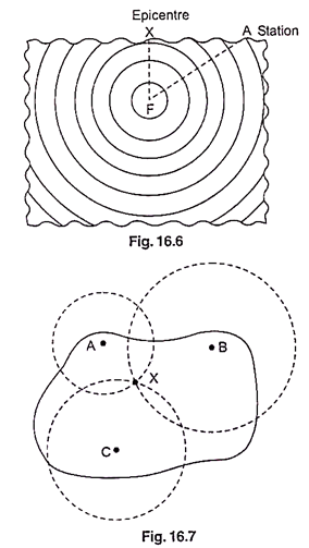
Fig. 16.6 shows how nearby stations can locate the focus. For instance the distance of the focus F from the station A is proportional to the (P-S) time at the station A.
Most earthquakes are shallow, less than 60 km, but a few are as deep as 700 km.
In a simple method the location of the epicenter is found through a straight forward triangulation. From timing information gathered from previous studies of explosions or of earthquakes from other regions, curves are constructed showing the average time required for P or 5 waves to travel various distances from an epicenter. These seismic travel time curves are the basic tools for determining the distance of any earthquake source from the seismograph that records it.
In the Fig. 16.7 consider three seismographic observatories A. B and C each of which records an earthquake and each of which lies in a different direction from the source of the waves. The observatory staffs, at the three stations can read the time of arrival of the P waves and sometimes that of S waves.
Because a P wave travels about twice as fast as an S wave, the farther the two waves travel, the wider becomes the gap separating the wave fronts.
Thus, if the arrival times of P and S waves are available, the interval between the two types of waves will give a direct measure of the distance to the focus. Three circles are then drawn, each centred on one of the stations, with radii equal to the computed distances. The three circles will intersect at a approximately at the required epicenter.
Essay # 12. Review of Structure of the Earth:
The following details are based on the findings from studies of earthquake waves. Information about the fluid core comes from the consideration of the density of the various earth shells. The density of the granitic layer is about 2.67 gm./cc and that of the basaltic layer is rather higher. But, the average density of the whole earth is 5.5 gm./cc.
This means, the core must be composed of material heavier to make up for the lighter outer layers. Calculations show that a density of 8 gm./cc for the core would be reasonably right. This figure is slightly higher than the density of iron and below that of nickel. Thus the core probably consists of a mixture of these two metals and is therefore called nifel (from symbols Ni and Fe).

At the outer boundary of the nifel there is a discontinuity, marked by a change in physical properties between it and the overlying mantle. The upper part of the mantle probably has the composition of olivine rock or peridotite. Above this come the layers of the crust again with the difference in the physical properties.
The term sial has been coined from the initial letters of silica and alumina. Correspondingly the basaltic layer is called sima (from silica and magnesia) and from its properties, is thought to be in a vitreous state (i.e., non-crystalline). The sial is crystalline and rigid but the sima lacks rigidity and will yield slowly to long term continued stresses.
The marked break at the base of the crust between sima and the mantle is known as Mohorovicic discontinuity. The several earth shells may have been formed while the earth was solidifying from an originally fluid condition, though other possibilities have also been suggested.
The more acid granitic material being lighter would rise and the heavier matter would sink, resulting in a stratification. The proportion of iron and other heavy metals probably increases with depth until the core is reached.
Essay # 13. Instruments for Measuring the Size of Earthquakes:
(i) Scale of Magnitude to Estimate the Size of Earthquakes:
In 1935 Charles Richter of the California Institute of Technology developed a magnitude scale (Richter Magnitude) using seismic records to estimate the relative sizes of earthquakes.

As shown in fig. 16.14 the Richter scale is based on the amplitude of the largest seismic wave (P, S or surface) recorded on a seismogram. Because seismic waves weaken as the distance between the earthquake focus and the seismograph increases (in a manner similar to light), Richter developed a method that accounted for the decrease in wave amplitude with increased distance.
Theoretically as long as equivalent instruments were used, monitoring stations at various locations would obtain the same Richter magnitude for each recorded earthquake. (Richter selected the Wood-Anderson seismograph as the standard recording device).
Although Richter scale has no upper limit, the largest magnitude records on Wood-Anderson seismograph were 8.9. These great shocks released approximately 1026 ergs of energy (roughly equivalent to 1 billion tons of TNT). Conversely earthquakes with a Richter magnitude less than 2.0 are not felt by humans. The table below shows how Richter magnitudes and their effects are related.

Earthquakes occur in various strength. Some powerful earthquakes produce wave amplitudes that are thousands of times larger than those generated by weak tremors.
To accommodate this wide variation, Richter used a logarithmic scale to express magnitude where a tenfold increase in wave amplitude corresponds to an increase of 1 on the magnitude scale. For example, the amount of ground shaking for a 5-magnitude earthquake is 10 times greater than that produced by an earthquake having a Richter magnitude of 4.
In addition each unit of Richter magnitude equates to roughly a 32 fold energy increase. For example, an earthquake with a magnitude of 6.5 releases 32 times more energy than one with a magnitude of 5.5 and roughly 1000 times more energy than a 4.5 magnitude earthquake. A major earthquake with a magnitude of 8.5 releases millions of times more energy than the smallest earthquakes felt by the humans.
Other Measurements of Ground Motion:
The instrument we had considered in the preceding discussion for the measurement of ground motion was based on simple pendulums that swing when the base of support was displaced by an earthquake. Other igneous devices have been conceived over the years, some of which have become a part of modern practice.
We know that as P waves pass through the rocks they alternately compress and dilate the rocks resulting in fluctuations in volume and hence in density. This property of the rock suggests that if water were placed in a large hole underneath the ground where it could not escape, and a tube were to connect the hole to the ground surface, then the squeezing of the volume of trapped water (which is practically incompressible) would force the level of water in the small outlet tube to rise and fall.
The change in water level would give a measure of the compressional component of the P wave motion. The water level will be unaffected by the shear S waves. Devises based on this principle called dilatometers were proposed in the early twentieth century.
During the 1950s and 1960s some attempts were made to use the water trapped underground as a dilatometer. Floats were placed in wells and the rise and fall of the float, much amplified by the great volume of water contained in the underground cavities, would be a measure of the wave motion in the earthquake.
Though these efforts did not prove practical, modern satisfactory instrumental dilatometers are used now a days for special purposes. In Japan dilatometers are operated not specifically to measure the seismic wave motion, but to measure the slow compression of the rocks that might precede an earthquake.
Another early device for measuring ground deformation is the strain meter which measures the changes in the distance between two monuments. Later, the American maker of seismographs, Hugo Benioff devised a more practical instrument called strain extensimeter which recorded variations in the distance between piers set in the ground 6 m apart.
The instrument measured the shifting length of the gap between one pier and a standard length tube extending from the other pier. In the earlier type, the tube was of steel and in the later type, it was replaced by a quartz tube to minimize expansions caused by temperature variations.
The distance between the two piers attached to the ground varies as the ground changes in length as a result of either the buildup of elastic strain or the release of strain in an earthquake. These variations are measured by placing an electronic motion detector in the gap.

Similar devices involving wires stretched between points have been used to measure the slow length changes of the ground due to the build up of elastic strain in the deforming rocks. Such measurements are important to understanding earthquake genesis.
Essay # 14. Earthquake Waves Near Epicenter:
Earthquake records obtained of stations within about 1500 km of an epicenter have yielded valuable information about the composition of the outer shells or crust of the earth.
On these seismograms two and sometimes three sets of P and S waves can be distinguished. They are denoted by Pg, Sg, P*, S* and P, S the last named pair being the first to arrive. The three sets of waves are thought to have travelled in three different crustal layers along parallel paths. (Fig. 16.15)

The velocities of these waves as determined by Jeffreys from European earthquake data are as follows:
Pg: 5.57 km/s
Sg: 3.36 km/s
P*: 6.50 km/s
S*: 3.74 km/s
P: 7.76 km/s
S: 4.36 km/s
These values correspond roughly to those found experimentally for granite, basalt and peridotite respectively. They are greater than the velocities in average sedimentary rocks (2 to 4 km/s) near the earth’s surface.
Thus there is evidence from seismology, which is in agreement with geological indications, that the earth has a crust composed of several distinct layers as shown in Fig. 16.15 (vertical scale exaggerated). The outermost layer is of granitic composition and is covered locally by sedimentary rocks of variable thickness.
It rests on a layer whose composition approximates to vitreous basalt and this in turn rests on ultrabasic peridotite at a depth of 30 km below the surface (varies from 25 km to 35 km). The average thickness of the granitic and basaltic layers is about 10 km and 20 km respectively. The sedimentary layer is discontinuous. The granitic layer is not everywhere present below the oceans.