
Essay on Traffic Regulation and Rules for Road Safety in India:- 1. Introduction to Traffic Regulation 2. Basic Rules for Road Use and Traffic Flow 3. Traffic Control Devices.
Essay on Traffic Regulation:
Traffic regulation is necessary to ensure safe and efficient movement of vehicles and pedestrians on roads. Formulation of suitable regulations for the control of vehicles, drivers, and other road users is aimed at achieving this. Such regulation and control should be consistent with the individual rights of road users without undue infringement.
Vehicles:
The control of vehicles involves matters dealing with registration, design details such as size and weight, fitness inspection, issue of route permits and the like.
Drivers:
The control of drivers involves the issue of driving licenses for two-wheelers, light motor vehicles and heavy motor vehicles or trucks, minimum requirements in tests for drivers, social responsibility and civil liability.
Motorcyclists, Cyclists and Pedestrians:
The control of other road users such as motorcyclists, cyclists and pedestrians involves regulations for the use of separate track, lanes or crossings for them.
Other Road-Users:
Include cycle rickshaws, hand-carts and animal-drawn vehicles. In view of the mixed character of traffic in our country, special attention is required in the formulation of traffic regulations to deal with this traffic.
The Motor Vehicles Act-1988 takes care of all these aspects.
Essay on the Basic Rules for Road Use and Traffic Flow:
There are fundamental traffic laws which are applicable throughout the country. For example, in India and the U.K, “Keep to the left” rule stipulates that the road user or vehicle shall, in general, keep to the left of the road or lane. In one-way streets and multi-lane highways, however, this rule may not be strictly followed. In countries like the USA and Canada, “Keep to the right” is followed.
The majority of the countries in the world follow “keep to the right” rule. If all the countries adopt a single rule, it would be easy for drivers to drive in a country other than their own. However, since driving rules differ from one country to another, adapting to a set of driving rules that are different from one’s parent country becomes quite challenging. Change-over from one rule to another involves the modification of highway structures, traffic control devices and even the manufacture of vehicles.
Overtaking:
In countries following “Keep to the left” rule, overtaking shall be done from the right. Of course, in some stretches, overtaking itself may be prohibited owing to sight distance restrictions and other considerations. Once again, in multi-lane highways the rule may not be enforced.
Turning:
In countries with the “Keep to the left” rule, left turning must be made from the lane nearest to the left side kerb of the street into the left lane nearest to the left side kerb. Similarly, a right turn manoeuvre must be made from the lane nearest to the centre line of the street into the left lane nearest to the centre line of the other street.
In India, appropriate hand signals are also used to indicate left turn, right turn, allowing overtaking operation, slowing down, Stopping, and so on.
Speed Regulations:
Regulation of speed is an important means of ensuring road safety. Speed limits should be appropriate to site conditions and should be realistic in order to curb drivers’ temptation to disregard them.
Speed limits should be related to the volume and character of traffic, the general geometric features of the road at the particular location, the pedestrian traffic, nature of the area—urban or rural, time of the day, and so on.
The process of stipulating different speed limits in different stretches of a road, also referred to as ‘Speed Zoning’, has an inherent effect of reducing accident rate and enhancing road safety.
One-Way Street:
The imposition of one-way traffic in certain streets/lanes is an important method of traffic regulation; the traffic is allowed only in one specific direction. This increases road safety, ensures smooth traffic flow, realizes the lane capacity and increases the average speed.
This method also reduces conflicts at intersections, which are potential sites of accidents.
Essay on Traffic Control Devices:
Traffic control devices are necessary to inform the road user about road practices consistent with safety and facilitating smooth traffic flow.
The requirements of a traffic control device are:
(i) It should compel the attention of the road user.
(ii) It should convey the meaning at a glance.
(iii) It should allow enough time for easy response.
(iv) It should command the respect of the road user.
These can be achieved by the following:
(i) The design of the device – size, colour, sound and illumination.
(ii) The position or placement with respect to the cone of vision of the driver (10° to 12° in the horizontal plane and 5° to 8° in the vertical plane), and in the required lane (it should be legible enough to be understood by the driver at the design speed.)
(iii) Maintenance, such that it is in good condition without any obstruction and with visibility in all weather conditions.
(iv) Uniformity in use with the same standards in all respects.
The following are the traffic control devices to be considered herein:
Traffic signs or Road signs serve the following functions:
(i) Warning the road user of dangerous situations sufficiently in advance.
(ii) Regulating traffic by informing the drivers when to stop, give way or reduce the speed, and making them aware of prohibited actions.
(iii) Providing information on directions and points of interest such as fuel stations, restaurants, parking information, taxi stand and so on.
Traffic signs are broadly classified as follows:
i. Cautionary or warning signs, to serve the first function.
ii. Regulatory or mandatory signs, to serve the second function.
iii. Informatory signs, to serve the third function.
Location of Traffic Signs:
i. Normally located on the left side of the road, they may have to be repeated as ‘overhead signs’, if necessary.
ii. They may be placed on the median of a divided carriageway, if placing on the left side is not considered effective.
iii. Location should be such that no obstruction is caused to the movement of vehicles or for pedestrians on the shoulder.
iv. Even existing utility posts like electric poles may be used, if found convenient.
v. No part of the sign should be less than 2m from the edge of the carriageway or 0.6m from the edge of the kerb.
vi. The bottom edge of the sign should not be less than 2m above the kerb.
Visibility of Traffic Signs:
Traffic signs, especially warning signs and regulatory signs, should be made perfectly visible by using luminous paints or reflective devices during nights; this would help in making any letters or numbers written on the signs legible for easy recognition by approaching drivers.
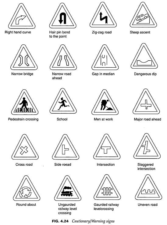
Cautionary or Warning Signs:
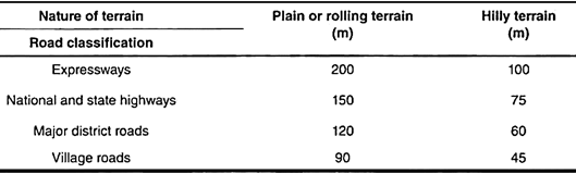
These are in the shape of an equilateral triangle with the apex pointing upwards. They are painted with a red border and black symbols on the white background. The normal size of the triangle is 900 mm side and it is 600 mm for small-sized signs, with border widths 70mm and 45 mm respectively. The signs should be located 50 m ahead of the points of hazard in urban areas.
In rural locations, this distance varies with the classification of the highway and the nature of the terrain, as given below (IRC: 67-2010).
Some common cautionary/warning signs are shown in Fig. 4.24.
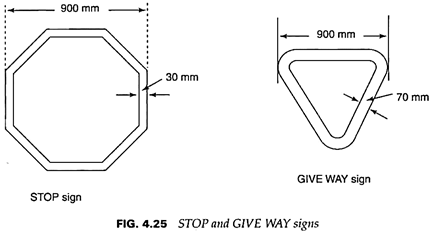
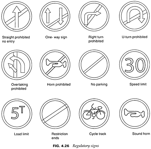
Regulatory or Mandatory Signs:
The two important signs of this category are the STOP and GIVE WAY signs. The ‘stop’ sign is octagonal in shape and is red in colour with a 30 mm white border; a small-sized version is 600 mm x 600 mm with a 20 mm white border. The other signs in this category are circular in shape with 600 mm diameter (normal size) or 400 mm diameter (small size) and are white in colour with a red border of 65 mm and 45 mm, respectively; the width of the red oblique bar is 60 mm and 40 mm respectively. A smaller size of 300 mm diameter may be used in conjunction with light signals or on bollards on traffic islands; the red border and red oblique bar for such signs are 35 mm and 30 mm, respectively.
The No Parking and No Stopping signs have a red border and red slanting bars but the background is blue instead of white.
The ‘Stop’ and ‘Give way’ signs are shown in Fig. 4.25 and the other regulatory signs are shown in Fig. 4.26.
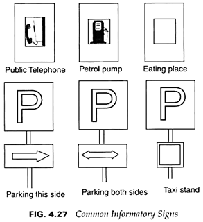
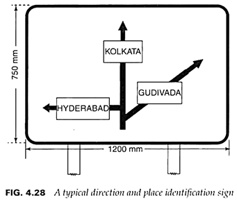
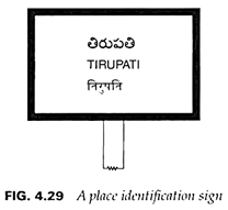
Informatory signs are usually rectangular in shape, 800 mm x 600 mm, for normal-sized sign and 600 mm x 450 mm for small-sized sign. For Parking Signs, the shape is square, 400 mm for normal size and 300 mm for small size. These signs have white background, black letters and arrows, and black border. The sizes of the various symbols are specified by the IRC. Some common informatory signs are shown in Fig. 4.27. A typical direction and place identification sign is shown in Fig. 4.28. A place identification sign is in Fig. 4.29.
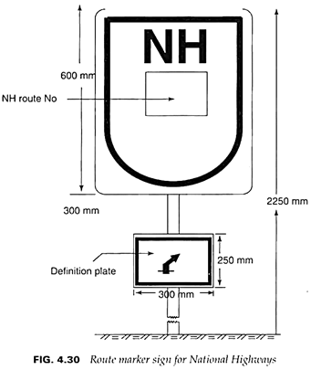
A route marker sign for national highways, standardised by the Indian roads congress, is shown Fig. 4.30.
Road markings are defined as lines, patterns, words or other devices set into, applied or attached to the carriageway or kerbs or to objects within or adjacent to the carriageway, for controlling, warning, guiding and informing the road users.
Road markings are used to control and guide traffic along its designated path, and aid pedestrians and cyclists in using their own paths or move into safe locations. This promotes road safety and ensures smooth flow of traffic, especially under mixed traffic conditions.
One inherent advantage of road markings is that they convey the necessary information to the driver without distracting their attention from the carriageway. Some limitations are obliteration by skidding of vehicle tyres and snow, poor visibility under wet conditions and renewals as and when necessary. The advantages of road markings far outweigh these limitations.
The material commonly used for road markings is paint; ordinary paints for this purpose are covered by the relevant Indian Standard Specification.
These paints do not provide a bright surface and they have a relatively short life. Hence, thermoplastic paints are applied for better visibility.
Night visibility can be enhanced by using minute glass beads set in the markings to produce a retro-reflective surface. Road studs and metal and plastic inserts are also used.
Road markings may be classified broadly into the following two types:
(a) Carriageway markings
(b) Object markings.
As the name indicates, these are markings applied or painted on the carriageway itself. These may be primarily longitudinal, but may be transverse as in the case of STOP lines and cyclist crossings. Miscellaneous symbols such as route direction arrows, word messages, parking space limits and bus stops may also be used, each for a specific purpose.
The following are the types of carriageway markings:
1. Centre line of the highway
2. Traffic lane lines
3. Markings for no-overtaking zones
4. Pavement edge lines
5. Transition markings for reduction of carriage width
6. Obstruction approach markings
7. Pedestrian crossings
8. Cyclist crossings
9. Markings at approaches to intersections
10. STOP lines
11. Route direction arrows
12. Word messages
13. Parking space limits
14. Bus stops
Some general principles of longitudinal carriageway markings are universally accepted:
1. Solid lines are regulatory or restrictive, and it is an offence to cross such lines, except when absolutely necessary to avoid a stationary obstruction or to enter or exit from a service road.
2. Broken lines, although generally restrictive in character, may be crossed consistent with safety
3. When solid and broken lines are used in combination, a vehicle should not cross the solid line adjacent to and to the left of a broken line on the right of the lane in which it is moving. This is applicable to countries in which the traffic keeps to the left. In the case of countries in which the traffic keeps to the right, left should be substituted by right, and vice-versa.
4. Double solid lines indicate maximum restriction and should not be crossed.
The colour of road markings in Indian practice is given below:
White – All carriageway markings except for parking restrictions.
Yellow – Markings for parking restrictions.
Traffic signals are utilised for safe movement of traffic at road intersections and to avoid possible conflicts between vehicles approaching the intersection from different directions. It is surprising to note that traffic signals were used in London as early as 1868. Although they were originally of the semaphore type with STOP/GO indications, lights were introduced for use during nights; manual operation was gradually replaced by automatic operation systems.
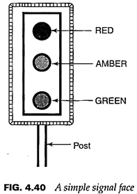
A traffic signal device is an assembly containing one or more signal faces; each comprises optical units which display colour-coded indications. In India, as in most countries around the world, three colours are used – red, amber and green. They may be fixed horizontally or vertically to a post; left to right in this sequence for the former arrangement and top to bottom for the latter.
RED indicates Stop and GREEN indicates Go; AMBER indicates the transition interval for clearance of the moving vehicles and as a Get Ready indication to the vehicles in the other stream which have been stopped earlier. A flashing red signal indicates that the vehicle stop and proceed with caution depending on the availability of a safe gap in the crossing stream. Flashing amber signal indicates that the vehicle may proceed with caution. A simple signal face with three lenses arranged in a vertical line, attached to a post of suitable height is shown in Fig. 4.40.
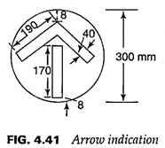
The lenses are normally of two sizes – 200 mm and 300 mm diameter. The larger size is used on roads where 85 percentile speed exceeds 65 km/h, as also for arrow indications (Fig. 4.41).
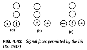
In addition to the simplest signal face (Fig. 4.40) a few more permitted by the above Indian Standard are shown in Figs. 4.42[(a), (b) and (c)].
In addition to signal posts adjacent to the carriageway, overhead signal posts at a height of 6.6 m above the road with a horizontal arm-length of 3m are also used in urban areas and cities to attach signal faces.
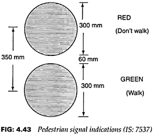
Pedestrian signal indications permitted by the ISI (IS: 7537) are shown in Fig. 4.43.
Detailed specifications for the illumination of signals are available in IS: 7537-1974.
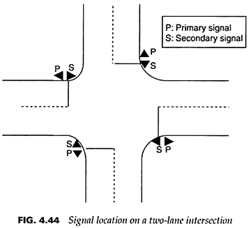
Regarding location of the traffic signals, it is desirable to provide at least two installations:
1. Primary signal near the stop line, 0.9m ahead of it.
2. Secondary signal diagonally opposite the primary signal.
A typical layout of signal installations for a two-lane intersection is shown in Fig. 4.44.
Traffic signals are needed for the regulation of conflicting streams of vehicles and pedestrians at intersections However, the Indian Roads Congress has laid down certain minimum conditions, called ‘warrants’, under which the installation of traffic conditions is justified.
The four warrants relate to:
1. Minimum vehicular volume
2. Interruption of continuous traffic flow on the Major Street and undue delay of traffic on the minor street.
3. Minimum pedestrian volume
4. Accident experience.
The details of these warrants are covered by the IRC specifications contained in IRC: 93-1985.
Advantages of Traffic Signals:
i. Orderly traffic flow and increase in traffic capacity of the intersection.
ii. Reduction of accidents – right-angled collisions and those involving pedestrians
iii. Continuous or nearly continuous movement of traffic
iv. Interruption of heavy traffic to assign right of way for pedestrians and slow-moving vehicles.
v. More economical than control by traffic police.
vi. Signal indications are clear even under unfavourable weather conditions and at night. Disadvantages
vii. Excessive delay during off-peak hours.
viii. Unwarranted signals encourage the drivers to disobey the signal indications.
ix. Increase in rear-end collisions
x. In case there is a break-down of the system due to power failure or for any other reason, it will lead to chaotic traffic conditions and unnecessary delay, especially during peak hours.
Classification of Traffic Signals Based on Operation:
(1) Fixed-time signals
(2) Traffic-actuated signals
(3) Co-ordinated or linked signals
These signals are set to repeat a cycle of red, amber and green lights regularly, with the timing of each of these phases being predetermined based on the expected traffic at the intersecting roads (obtained from the traffic studies). The sum of the durations of the three phases is the cycle length (in time units). These are electrically operated and the simplest type of automatic signals.
Fixed-time signals are efficient when traffic patterns are relatively stable for significantly long periods moving to the consistency of repetition of the cycles, and linking with adjacent signals and signal networks is relatively easy. However, this type of signaling system is disadvantageous during off-peak hours since excessive delays occur as the timings of each phase is fixed However, different sequences of the cycles (with predetermined phase times) can be set by automatic or manual switching.
(2) Traffic-Actuated Signals:
In this type, detector devices are placed on the carriageway a little ahead of the stop line. As the vehicle approaches, the detector actuates the signal mechanism to flash or extend the green period based on the traffic demands.
In a fully traffic-actuated system, detectors are placed on all the legs of the intersection, and the right of way is assigned by a computer programmed in a certain manner to respond to the traffic needs.
In a semi-traffic-actuated system, detectors are placed on the minor roads at the intersection, while the right of way is normally given to the traffic on the major roads.
Since these signal systems are expensive, in developing countries traffic police are assigned the duty of varying the phase- and cycle-time of the signals according to traffic demands.
Co-Ordinated or Linked Signals:
If the individual signal systems along a city thoroughfare with intersections at frequent intervals are co-ordinated such that a vehicle moving along the thoroughfare at normal speed need not have to stop at a very intersection for getting the green indication, it gets a thorough land and there will be minimum delay. This results in increased capacity along the co-ordinated route.
This co-ordination may be achieved by the following systems:
1. Simultaneous system
2. Alternate or limited progressive system
3. Simple progressive system
4. Flexible progressive system
1. Simultaneous System:
In this system, all the signals along a given road show the same indication at the same time; the phase times and the cycle lengths are all same. This results in simultaneous stoppage of all the traffic along the road and increases the tendency of the drivers to speed up between intersections. It also causes inconvenience to traffic from side roads trying to enter or cross the traffic on the main road. Thus there will be a significant reduction in road capacity.
2. Alternate or Limited Progressive System:
In this system, consecutive signal installations show contrary indications at a given time. This limits speeding but will result in inefficient handling of traffic at most intersections. Although better than the simultaneous system, it is not suitable when the block lengths are unequal.
3. Simple Progressive System:
Under this system, the different signals along a road display green indications according to a time schedule to permit a reasonably continuous movement of vehicles, although at different speeds in different blocks.
The offsets at the installations are determined so as to secure the best possible continuous movement in both the directions. (Offset, in this context, means the difference between the starts of green phase at the successive upstream and downstream signals. It is important in planning a system of co-ordination). Each signal installation may have a different cycle division, which remains fixed throughout the day.
4. Flexible Progressive System:
Under this system, it is possible to vary the cycle length, cycle division, time schedule and the offset at each of the signal installations automatically with the aid of a master controller. This results in the best possible movement of the traffic stream at approximately the design speed. This is expensive but is justified in cities where traffic is very heavy.
The multitude of signal installations in an area can cause delays unless their operations are controlled through a master computer. The system of centralised traffic control of large areas as in the cities is known as ‘Area Traffic Control’.
This requires the following:
i. Sensors or detector devices set beneath the carriageway to record the arrival of vehicles from the approach roads.
ii. Cables to transmit the impulses to a master controller or central computer
iii. A master controller with pre-programmed signal cycle plans, to minimise vehicle delays at intersections.
Area traffic control is successfully practised in metros and big cities.
4. Miscellaneous Traffic Control Aids:
In this category, there are several traffic control aids like delineators, which are light-retro- reflecting devices for safe night-driving – roadway indicators, hazard markers and object markers.
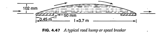
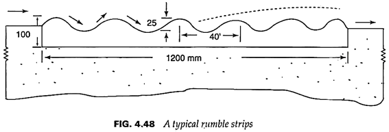
Under traffic calming devices are speed breakers or humps, rumble strips and crash cushions. A speed control hump is shown in Fig. 4.47.
A typical rumble strip is shown in Fig. 4.48.
Intelligent Transport Systems (ITS):
Also known as transport telematics, these are transport systems that utilise modern information technologies to improve the operation of transportation networks. Information technology has been successfully applied for acquiring large volumes of data on travel patterns, volumes, speeds, load carried and a host of other information in a city, processing and applying the results to guide traffic, enhance road safety, reduce transport costs, and improve traffic operations.
ITS has a wide variety of applications such as:
1. Monitoring traffic flow, providing information to drivers on traffic congestion, alternative routes, speeds to be observed, road closures and weather conditions. For this purpose, Advanced Traveller Information System (ATIS) is used.
2. Providing advanced vehicle control systems (AVCS) to dispense with human control of vehicles and rely on computers.
3. Using electronic devices for longitudinal and lateral guidance of vehicles.
4. Adjusting signal operations to relieve traffic congestion and improving traffic flow. Advanced traffic management system (ATMS) is used for this purpose.
5. Monitoring vehicle breakdowns and accidents
6. Optimising maintenance interventions and asset management
7. Using geographic information systems (GIS) for public transport management system
8. Collecting toll on highways through electronic methods
9. Using advanced public transportation system (APTS) package for optimum utilisation of mass transport systems including light rail, tube rail and other alternative modes of travel.
Intelligent transport systems are in use in advanced countries such as the USA, the UK, France, Canada, Australia, Japan and China. ITS applications are in the developing stage in India; however, certain systems based on ITS are being used in metropolitan cities. For example, the Mumbai-Pune Expressway has a centralised traffic control system.
ITS thus has a lot of potential and is set to play a key role in the efficient operation of future transportation facilities.
5. Traffic Islands:
These are raised constructions within the roadway by means of which traffic may be guided physically along definite paths. Traffic islands help in segregating fast traffic and slow-moving vehicles, minimising traffic conflicts and conflict areas within an intersection, smoothening traffic flow, and improving traffic safety.
Traffic islands often serve different functions; from this angle, they may be classified as follows:
(a) Channelising Islands:
These are used to separate traffic streams and guide them into definite travel paths to improve traffic safety by reducing conflicts.
(b) Divisional Islands:
These are provided on highways of four or more lanes to segregate opposing traffic flows.
This automatically prevents head-on collisions. The height should be adequate to prevent vehicles from entering into the islands.
The width of divisional islands should be adequate to prevent head-light glare of opposing traffic from affecting the driver’s vision and judgment. They should be long enough to accommodate one-way traffic of the expected capacity, especially near intersections.
(c) Refuge Islands:
These are islands constructed in the middle of pedestrian markings or cross-wall lines; they are specifically meant as refuge for pedestrians who wait to cross the next lane after having crossed one, watching the traffic for a safe opportunity to walk across.
(d) Passenger Loading Islands:
These are provided at regular bus stops for the protection of passengers alighting from or boarding buses, before they move away from the carriageway.
(e) Rotary:
This is one of the most popular channelised intersections. Usually they involve cross-roads, or multi-arm intersections. A rotary intersection is invariably signalised; in case it is not, it is called a roundabout.