
Everthing you need to know about controlling floods in India.
Contents:
- Introduction to Flood Control
- Classification of Methods for Flood Content
- Design Flood and Its Estimation
- Flood Control Reservoirs
- Diverting the Flood Waters through Flood Ways
- Confining Flood Flow between Levees and Flood Walls
- Benefits of Flood Control
- Recommendations of National Policy on Flood Control
1. Introduction to Flood Control:
Flood is a relatively high flow. The floods cause overtopping of natural as well as artificial banks of the streams. The flood is caused by run off from rainfall and/ or melting snow, too large to be confined in the banks of streams. When banks are overtopped the flood water spreads over the adjoining area and causes heavy damage to crops and property.
It is not possible to prevent occurrence of floods but it is possible to prevent or reduce the damage due to floods by controlling the floods. This flood control or flood management may be defined as the prevention or reduction of the flood damage.
In India about 40 million hectares of area has been identified as flood prone. Out of this about 12 million hectares have been provided with flood protections measures by March 1982. Govt. of India set up National Flood Commission in July 1976. The main function of this Commission is to study in depth the effectiveness of the works so far undertaken and recommend measures to be adopted.
2.
Classification of Methods for Flood Content:
The loom flood control is also sometimes referred as flood management.
According to National Flood Commission 1976 the broad classification of method of flood control are as follows:
1. Methods by which attempt is made to modify the flood.
2. Methods by which attempt is made to modify the susceptibility of flood damage.
3. Methods by attempt is made to modify the loss burden.
4. Bearing the loss.
The National Flood Commission has given a very broad Table which gives very elaborate classification of the method of flood control but of this table, the methods of flood control commonly adopted has been listed below.
1. Reducing the peak flood flow by constructing reservoirs.
2. Diverting the flood waters through flood ways or bypasses.
3. Confining the flood flow within predetermined channel by levees, flood walls.
4. Reducing of peak stage by a closed conduit improving outflow channels.
5. Temporary or permanent evacuation of the flood plains.
6. Reducing flood run-off by land management.
7. Flood proofing of specific properties.
3.
Design Flood and Its Estimation:
The design flood is the flood adopted for the design of a flood control project. This flood may either be the maximum probable flood or the standard project flood or a flood corresponding to some desired frequency of occurrence depending upon the degree of protection that should be provided by the flood control project.
The maximum probable flood is the flood which may be expected from the most severe combination of critical meteorologic and hydrologic conditions which are most likely in the region. It is estimated from the maximum probable storm applying the principle of unit hydrograph.
The standard project flood is the flood which is expected from the most severe combination of meteorologic and hydrologic conditions which are reasonably possible in the region. It is determined from the standard project storm rainfall applying the principle of unit hydrograph. The standard project flood is about 50% of the maximum probable flood for the area.
If it was feasible within acceptable limits of cost it would be ideal to provide protection against the maximum probable flood. But it is seldom practicable. Hence some risk has to be accepted in the selection of the design flood.
Following are the methods which can be used for estimation of design flood:
1. Empirical flood formulae.
2. Applying suitable factor of safety to maximum historical flood ever occurred.
3. Envelope curves.
4. Frequency analysis.
5. Rational method of derivation of design flood from storm studies and application of unit hydrograph principle.
Dicken’s formula, Ryve’s formula and Inglis formula are used to estimate peak flow. These formulae are the functions of catchment area and a coefficient. Safety factor method depends on the judgement of the designer and hence its use is limited.
In the envelope curve method maximum flood is obtained from the envelope curve of all the observed maximum floods for a number of catchments in a homogeneous meteorological region plotted against drainage area. This method is unreliable. Frequency method involves the statistical analysis of observed data of a fairly long (at least 25 years) period.
As this method is purely statistical it should be used with caution. Rational method involves several studies and use of unit hydrograph and hence is the most reliable. However the principle of unit hydrograph cannot be used for catchments less than 25 km2 and over 5000 km2. For the results to be realistic large number of raingauge stations have to be established in the entire catchment so that true weighted rainfall of the catchment is reflected.
4.
Flood Control Reservoirs:
The main purpose of flood control reservoir is to temporarily or permanently store a portion of the flood flow so as to lower the flood peak at the point to be protected. This is achieved by discharging all reservoir inflow until the outflow reaches the safe capacity of the d/s channel.
All flow above this rate is stored until inflow drops below the safe d/c channel capacity. The stored water thereafter is released to recover storage capacity for the next flood. Since the reservoir is located immediately U/ S from the point to be protected, the hydrograph at that point is same as that released at the dam, and the peak has been reduced.
The most effective location of reservoir for flood control of an area is immediately U/ S from the area. Such a reservoir would often be located in a broad flood plain and very large area of valuable land would be submerged in the reservoir. Besides it will also need a very long dam. On the other hand the sites farther U/S require smaller dams and less valuable land but are less effective in dropping flood peaks.
The loss is the effectiveness results from the influence of channel storage and also from the lack of control over the local inflow between the reservoir and the area to be protected. If the local area is between the reservoir and the point to be protected in sufficiently large, it may produce a flood over which the reservoir would have little or no control.
It should also be noted that a single reservoir cannot give equal protection to a number of points located at different distances d/s. Hence criterion for evaluating a flood control reservoir or a system of reservoirs is the percent of the low drainage area controlled by the reservoirs.
Normally, at least one-third of the total discharge area should be under reservoir control for effective flood reduction. Economic analysis generally favours the U/S site despite its lesser effectiveness. Moreover, it is often preferred to establish several small reservoirs rather than having a single large reservoir.
The possible drop is peak flow by reservoir operation increases as reservoir capacity increases, since a greater portion of the flood water can be stored. Hence, a second criterion for evaluation of a flood-control reservoir is its storage capacity.
The flood-control reservoirs are of two types:
1. Detention reservoirs, and
2. Retarding reservoirs.
The detention reservoir is provided with outlets and spillways controlled by gates and valves which are operated on the judgement of the project engineer. The detention reservoirs for flood control differ from conservation reservoirs only in the sense that former used a layer sluice way capacity to permit rapid drawdown in advance of or after a flood.
The retarding reservoir consists of ungated outlets which automatically regulate the outflow according to the volume of water in the storage. The outlet usually consists of a large ungated spillway or one or more ungated sluice ways. The discharge capacity of a retarding basin with full reservoir capacity should equal the maximum flow which the channel d/s can pass without causing serious flood damage.
5.
Diverting the Flood Waters through Flood Ways:
Flood ways are the large depressions into which a part of flood water is diverted through natural or artificial channels. The diverted flood water remains temporarily stored during the rising flood. Once the flood recedes in the river, the water stored in this depressions is allowed to flow back to the river.
The flood ways thus serve two purposes firstly they create large, shallow reservoirs which store a part of the flood water and hence decrease the flow in the main channel below the diversion. Secondly, they provide an additional outlet for water from U/ S, thus increasing velocity and decreasing stage for some distance above the point of diversion.
6.
Confining Flood Flow between Levees and Flood Walls:
A levee is an earth dyke, while a flood wall is usually made of masonry or concrete. Levees and flood walls are the oldest and most widely used methods of protecting land from flood water. These are nothing but longitudinal dams aligned roughly parallel to the river. They serve as artificial high banks of the river and thus prevent the river water from spilling over during floods.
The flood water remains confined between the levees or flood walls and is made to flow down the river without causing any damage to the adjoining area. The levees should be so located that a sufficient channel is available to pass out the design flow with a reasonable free board against wave action.
The channel width between levees and the height of the levees are closely related. When a city or any area is to be protected a ring levee which completely encircles the area may be provided.
Reducing the Peak Stage by Improving the Outflow Channel:
Outflow channels if improved for its hydraulic properties carry higher flood waters.
This improvements may be:
(a) Increasing the velocity of flow in the channel
(b) Realigning the channel along the shorter route
(c) Increasing the cross-section of the channel
(d) Enlarging the water ways to drainage crossings.
All these measures tend to reduce the prevailing water level for the corresponding flood discharge. It may however, be stated that although the channel improvement is a well recognised method for flood control, it should be used with caution.
This is so because the measures adopted in this method are essentially local protection measures which may increase flood magnitude at d/s points on account of accelerated flow of run-off from the upper improved reaches of the channel.
Evacuation from Flood Plain:
Emergency evacuation from flood threatened area is the most effective method of reducing damage due to floods. With reliable flood forecasts this method may be adopted for sparsely populated areas where property values do not justify the use of other methods of flood control and the loss of life can be avoided by prompt evacuation.
However the effectiveness of this method depends on the hydrologic characteristics of the stream as well as the availability of good flood forecasting service so that sufficiently in advance warning of floods could be given to the area to complete evacuation.
The term Flood plain zoning is defined as the method of dividing the entire flood plain area into different zones and to restrict the occupancy of the different zones of the flood plain to uses which will suffer little or no damage during floods.
The objectives of zoning of the flood plains are discussed as follows:
1. Avoiding encroachment of waterway of the river. Such encroachments aggravate the flood problem and result in heavy flood damage.
2. Directing activities in other parts of the flood plain in such a manner that they are less susceptible to damages in case of floods.
Like any other measure of flood control, the flood plain zoning must also be adopted only if it is economically justified.
Reducing Flood Run-Off Land Management:
It is known that vegetal cover removes moisture from the soil by transpiration. It also promotes loose organic soil which is favourable for the infiltration of rainfall. Further a heavy vegetal cover also results in high interception loss during floods.
Water conservation measures help to conserve or store water in the soil and thus reduce surface run-off and the flood flows.
Following conservation measures can be used:
1. Use contour farming
2. Create farm ponds to retain the flow of small creeks for irrigation
3. Use of cover crops is field to avoid bare followed field during non-growing season.
However all these measure of water conservation are quite useful for reduction of soil erosion and preservation of soil-moisture, they are invariably used and any flood reduction taking place from these is an incidental benefit.
Flood Proofing of Specific Properties:
Isolated units of high value may sometimes have to be individually flood proofed. The property unit may be encircled by a high levee of as flood wall.
Flood Plain Management:
The flood plain of a river is formed by deposition of sediment. Since the flood plains are nearly level they prove good sites for cities. This results is the occupancy of the flood plains. This however requires large annual expenditure for flood protection and such expenditure continues to increase unless a systematic approach to flood plain management is adopted. The flood plain management should reduce the costs of flood plain occupance.
The costs involved are:
1. The initial cost of development
2. The cost of flood protection
3. The residual flood damage and
4. The costs of relief and rehabilitation
The tools used for flood plain management are as follows:
1. Flood Hazard Surveys:
The detailed survey of the flood plain is conducted and flood marks of previous floods are noted. Surveys help to assess the probability levels of floods at various points and provide the basic information for defining flood risks.
2. Flood Plain Zoning:
It is a device by which occupancy of the flood plain is prohibited. The land is left either in their natural state or used for parks and other recreational purposes.
3. Flood Proofing:
It is method which can be used to project individual properties from damage due to floods.
4. Flood Insurance:
In order to restrict or discourage the unwise use of flood plains a programme of flood insurance may be adopted. The premium of insurance should reflect the risk involved in undertaking the construction in the flood prone area.
5. Economics of Flood Control:
Adoption of only one type of flood control method for the entire river is rare. Economic analysis also speaks use of combination of different flood control methods.
The project is which several flood control methods are jointly used is known as combined project. Often reservoir construction is combined with construction of levees and improvement in outflow channel at key points along the stream. The cost analysis for such a project is shown in Fig. 9.19.
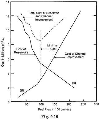
If several reservoir sites are available they should all be exploited. It is fact that with more reservoirs being constructed, smaller regulated peak flow is obtained as shown in curve A of Fig. 9.19.
Since only reservoirs would not provide complete protection, levees and other channel improvements would be necessary. Curve B reflects the costs of these works for protection against various flows. The sum of curves A and B gives the total cost of protection against the design flood.
The construction of curves of this Fig. 9.19 requires the design of channel works for protection against several different flows.
7.
Benefits of Flood Control:
The benefits of flood control measures may be classified under the following two heads:
1. Tangible Benefits:
Tangible benefit of flood control measures may be considered under following two heads:
(a) Benefits arising from prevention of flood damage
(b) Those occurring from more intensive use of protected land.
The tangible benefit may also be classed as:
(i) Primary benefits and
(ii) Secondary benefits.
The primary benefit are:
1. Cost of replacing or repairing of affected property
2. Cost of evacuation, relief and rehabilitation of affected people and other emergency flood projection measures.
3. Losses as a result of disruption of business etc.
4. Loss of crops.
The flood damages in the affected area should be carefully estimated. This is generally done after the occurrence of major floods when the damage is clearly evident.
Land protected from floods may be used for more useful use which may be in form of agriculture or industry. Increase in land value may be converted into average annual benefit. Secondary benefits are difficult to assess and hence usually not included in the cost estimates of flood control benefits.
Intangible Benefits:
Intangible benefits of flood control include prevention of loss of life and reduction in disease resulting from flood conditions. It is difficult to place a monetary value on the intangible benefit.
The final step in the economic analysis of a project is a comparison of the benefits and costs. Protection against the rare floods is uneconomical because of the large investment and infrequent flood occurrence. Actually for many flood control works the design criteria cannot be based on a direct economic analysis. Thus only those portions of a project which are in themselves beneficial should be constructed. Any project must show economic feasibility before it is undertaken for construction.
8.
Recommendations of National Policy on Flood Control:
Board recommendations are as follows:
1. In order to deal the problem of floods on a comprehensive basis very sustained and systematic efforts are needed, both at administration level and general public level. These tasks are very huge is magnitude and hence measures of protection from floods should be progressively undertaken so that increased protection from floods is achieved every year.
2. Even the best flood control measures do not provide complete protection and are aimed at providing a reasonable degree of protection. Reason for this being economically unjustified.
3. State governments are primarily responsible for flood control measure projects, Central Govt. should also take initiative in the matter.
4. Flood control measures should form an integrated part of the overall development of the region in respect of water resources, economic perspective, ecological and humanitarian considerations.
5. The flood management in particular areas should form a part of package of measures of comprehensive plan for that area. Different alternatives with various degree of min of measures should be worked out and analysed for optimisation.
6. Reservoirs must he considered as an important component in any package of measures provided they are technically and economically viable.
7. Use of natural detention basins for flood moderation should be used if condition permit.
8. Channel improvement measures should be considered with due caution because they are costly in initial as well as maintenance cost.
9. While using embankments, their side effects and associated problems should be carefully studied.
10. Measures like flood plain regulation, flood forecasting and warning, flood proofing, disaster preparedness should be adopted to reduce the susceptibility to life and property. This is essential as engineering measures by themselves cannot provide protection from all floods.
11. Disaster relief, remission of Tanes, provision of taccavi loan etc. should be continued on humanitarian considerations. Crop insurance and insurance schemes for damage to properties should be liberally continued.
12. Anti-erosion works should be taken up for protection of railway lines, roads, industrial areas, towns, group of villages where the benefit cost ratio justifies such works.
13. Afforestation and soil conservation measures are useful complements to other measures and should be; considered specially in the watersheds of streams charged with heavy silt load.