
Here is an essay on ‘Jammu and Kashmir’ for class 7, 8, 9, 10, 11 and 12. Find paragraphs, long and short essays on ‘Jammu and Kashmir’ especially written for school and college students.
Essay on Jammu and Kashmir
Essay Contents:
- Essay on the History of Jammu District
- Essay on the Location of Jammu and Kashmir
- Essay on the Administrative Set Up in Jammu
- Essay on the Physiography of Jammu and Kashmir
- Essay on the Drainage System in Jammu and Kashmir
- Essay on the Soil of Jammu District
- Essay on the Climate of Jammu and Kashmir
- Essay on the Flora and Fauna of Jammu District
Jammu and Kashmir State constitutes the northern most extremity of India. The state of Jammu and Kashmir is located between 32° 17’to 37° 06′ N latitude and 73° 26′ to 80° 30′ E longitude. Jammu and Kashmir is home to several valleys such as the Kashmir Valley, Tawi Valley, Chenab Valley, Poonch Valley, Sind Valley and Lidder Valley. Jammu and Kashmir is founded by Maharaja Ghulab Singh by integrating four regions viz. Jammu, Ladakh, Kashmir and Gilgit.
Jammu and Kashmir consists of three regions- Jammu, the Kashmir valley and Ladakh, which consists of overall 22 districts. Jammu region has 10 districts viz. Jammu, Kathua, Samba, Udhampur, Reasi, Doda, Poonch, Kishtwar, Rajouri and Ramban, whereas Kashmir region has 10 districts namely Kupwara, Budgam, Baramulla, Bandipora, Srinagar, Ganderbal, Pulwama, Shupiyan, Anantnag and Kulgam. However, Ladakh region comprises of only two districts i.e. Leh and Kargil. Srinagar is the summer capital, and Jammu is the winter capital.
Essay # 1. History of Jammu District:
Jammu was one of the important principalities along with other districts of Jammu region well before and during the earlier phase of Mughal rule. In 12th century A.D when Mohd. Gauri invaded India and over Punjab, Rajputs took refuge in the mountainous tract of Jammu region and carved out separate estates which they rule as independent sovereigns. After the disintegration of Mughal Kingdom, however, the rajas recovered their strength and proclaimed their independence once again.
With the installation of Sikh rule in Punjab, however, Jammu and all other adjoining areas were annexed by Maharaja Ranjit Singh with his territories. Mian Kishore Singh who was the direct descendent of Raja Dhruv Dev, an earlier ruler of Jammu, held a prominent and respectable position in the court of Maharaja Ranjit Singh at Lahore. His son Gulab Singh joined the army of Ranjit Singh while in teens and in course of time distinguished himself as a gallant warrior and became an accredited lieutenant of Ranjit Singh.
Gulab Singh was eventually made the Raja of Jammu by the treaty of Amritsar dated 13-03-1846. Later on, he annexed Kashmir with Jammu as a result of the sale deed executed by the British after the fall Sikh rule in Punjab.
The descendants of Maharaja Gulab Singh ruled over Jammu and Kashmir up to 1948 when Maharaja Hari Singh left the state and his son Yuvraj Karan Singh was appointed Regent. With the enactment of a new constitution for the state which was adopted on 17th November, 1956, the monarchy came to a final end, but Jammu has continued to retain its importance as the winter capital for the state government.
Like all other districts of the state, Jammu district also derives its name from its headquarter, the city of Jammu. Historians are unanimous in the view that the city was originally founded by Raja Jamboo Lochan who lived in 14th century B.C. It is said that the Raja had gone out one day for hunting when he happened to witness a tiger and a goat drinking water from one and the same pond.
This extraordinary phenomenon set him thinking and he decided to build a city at this site so that the strong and the weak could live together in peace and mutual tolerance. Eventually, he founded the city which came to be known as ‘Jamboo’ after his own name. With the passage of time and due to its frequent use, the pronunciation of the name got slightly distorted and the city came to be known as ‘Jammu’ as it is called now.
Essay # 2. Location of Jammu and Kashmir:
Jammu District is located between 74° 24′ and 75° 18′, East longitude and 32° 50′ and 33° 30′ North latitude. It is approximately 600 Kms away from National Capital, New Delhi and is linked with National Highway, NH44 (earlier NH1 A). Jammu District is situated on a hillock, on the bank of river Tawi and is bound by Udhampur district in the north and northeast, Kathua district in the east and southeast, Pakistan (Sialkot) in west and Rajouri district and POK (Bhimber) in the northwest. The city has numerous shrines for Muslims, Sikhs & Christians.
Jammu also serves as base camp for the holy shrine of Vaishno Devi and is the Railhead of the state. The Jammu District covers an area of3095 Sq. Kms. The original inhabitants are Dogras, which are also the major ethnic group but an influx of Kashmir’s Migrant and peoples of other parts of the state has changed the past scenario. The major proportion of the population consists of Hindus, Muslims, Sikhs, Jains, Buddhist and Christian in lesser proportion.
Essay # 3. Administrative Set Up in Jammu:
Jammu district derives its name from its headquarters and state’s winter capital popularly known as city of temples. Administratively, Jammu region has 10 districts viz. Jammu, Kathua, Samba, Udhampur, Reasi, Doda, Poonch, Kishtwar, Rajouri and Ramban. The area under study i.e. Jammu district is in Jammu region which comprises of four tehsils viz. Akhnoor, Bishnah, Ranbir Singh Pura and Jammu, which were reorganized in 2004, but in 2001 Jammu District had Five Tehsils viz. Akhnoor, Bishnah, Jammu, Samba, R.S.Pura.
The district consists of eight blocks i.e. Akhnoor, Bhalwal, Bishnah, Khour, Marh, Ranbir Singh Pura, Satwari and Dansal. Jammu district has a National Airport situated at Satwari. Jammu district serves as the winter capital of Jammu and Kashmir State from November to April when all offices move from Srinagar to Jammu.
Essay # 4. Physiography of Jammu and Kashmir:
Jammu district is situated in the sub-mountainous region at the foot hills of the Himalayas. The northern, north-eastern and north-western areas form a part of the Himalayan foot hills with a number of low lying ridges, strike and transverse valleys. The hills, in general have their southern slope comparatively gentler than the northern prominent hill scarps. The hills gradually merge in the plains where topography is gently undulating and flat. The mean sea level increases from 320 meters at Jammu to 1207 meters at Kalidhar near Chauki Chaura.
Jammu district has been divided into four sub-micro regions on the basis of geo-physical conditions of the district, the detail of each region are given below:
The region is located in the north western corner of the Jammu district and forms a part of the slopes of Siwalik range which runs at the top of the district. The area is comprised of the lower hills of Siwalik which are locally called as Kalidhar Mountains which separate the district Jammu from district Rajouri.
The road leading to Rajouri and Poonch districts passes through the Kalidhar mountains. Because of the irregular and uneven topography, the land is full of narrow valleys combined with deep cut hills and perennial/ non- perennial rivers/ nallas. The area is full of pine trees, sisham and variety of shrubs.
The average height of the region is about 608 meters with Kalidhar peak rising as high as 1204 meters. The main river of sub-micro region is Chenab. The other important river of the region is Manawar Wali Tawi followed by Tawi Khad. Apart, from these, there are also a number of small rivers/ rivulets and streams flowing through the region. The area of this region is not easily accessible being comprised of undulating topography.
The region is located around the two main rivers of the district viz., river Chenab and Tawi River and includes plain areas only. The region is spread over the south-western and middle parts of the district. The region occupies a large part of Tehsil Jammu but areas of Akhnoor and Ranbir Singh Pura Tehsils also fall in the sub-micro region.
The region has international boundary with Pakistan in the south and south western parts and the territory illegally occupied by Pakistan in the west. The region is situated at an average height of 750 meters having undulating area in the north eastern side and plain area in the south west which is very fertile due to the fact that the major river accompanied by their tributaries bring the fertile soil with water, which get settled in the plain areas.
The region forms a part of the region of Siwalik range, running in the northern part of the district. The region is spread over the upper north eastern part of the district, with an average height of about 600 meters. The height of about 600 meters in the north gets gradually merged with plains, forming a sub-montane belt. The seasonal torrents which are large in number flow down the slopes of Siwalik and bring with the silt, gravels, boulders etc. which they spread in plains.
The main rivers of the region are Tawi, Basantar and Devak besides a number of small and large perennial and non-perennial streams and rivulets originating from Siwalik. Forests are spread over a large part of the region leaving a few patches mostly on the banks of rivers/ streams for cultivation.
The region is situated in the southern-most part of the district and has undulating areas which are contiguous with Punjab plain in the south and Siwalik range in the north. The region has international boundary with Pakistan on its west and south whereas district Kathua falls towards its south eastern side. The region is spread over a major part of tehsil Ranbir Singh Pura, whole of Bishna, south western part of Samba tehsil and south eastern parts of Jammu Tehsil where the maximum contour height does not exceeds 500 meters.
The land is very fertile and cultivation is plenty. There is no forest in the region but the growth of shrubs is dense. The main rivers of this region are Basantar River and Aik Nalla which along with many tributaries spread sand, gravel, loamy soil and boulders in the plain areas of the region.
The accessibility to the region is exceptionally good as compared to the others areas of the district with National Highway NH44 passing from east to west and connecting many towns and villages of the area. Apart from this, there are also a number of other roads of varying specifications giving access to its important places.
Essay # 5. Drainage System in Jammu and Kashmir:
The Tawi, the Chenab, the Ujh and the Basantar are the main rivers constituting the drainage network of Jammu district. Besides these, various, nallahs, and choes having north south flow are also spread over the area. The Tawi originates from the base of snow field above Bhaderwah in the middle Himalayas, at an altitude of 4220 meters. The Tawi River passes through narrow valleys and ultimately debouches into a wide alluvial plain in and around the Jammu city.
The two important branches of the Tawi are the Nikki Tawi and the Baddi Tawi. Both the streams have braided pattern. The second important river in the study area is the Chenab. The Chenab enters the plain tract at Akhnoor and becomes braided. Some of the channels so formed get separated from the main stream and follow their own courses in responses to the gradient variations.
The river Chenab gets flooded frequently especially during rainy season. Thus, the flood plain of Chenab is wide and marshy. The Ranbir canal and Pratap canal which irrigates the different Tehsils of Jammu district are taken out of this mighty river of Chenab at Akhnoor. The Basantar, the Devak and the Bein are the important streams in the study area. The nallahs and choes are in large numbers. They remain practically dry throughout the year except in rainy seasons when they get inundated and cause damage to crops and property.
Essay # 6. Soil of Jammu District:
Soils of Jammu District are not of uniform nature they are quite diverse due to variable rock formations, terrain, climatic and floral conditions.
National Soil Atlas of India has divided the soil covers of Jammu district into following types:
1. Bhabar Soil.
2. Brown, Red and Yellow Soil.
3. Montane Meadow Soil
The narrow slope in the foothills of Siwalik extending from east to west including the Tehsils of Bishnah, Ranbir Singh Pura, Akhnoor and Southern portions of Jammu are characterized by typical Bhabar soils. The soils in the area have been formed by the mechanically transported alluvium from the adjoining Siwaliks and the Himalayan ranges comprising small pebbles and gravels. These soils are moderately alkaline in reaction. These soils are generally deficient in humus contents as the organic matter varies from 0.5 to 0.9 percent and nitrogen content ranges from 0.05 to 0.06 percent.
2. Brown, Red and Yellow Soil:
These soils are mainly developed over sandstone, grey micaceous sand stone and shales. The pH values vary from 6.0 to 7.6% and as such are neutral soils. Soils found in Siwaliks, which are composed of young tertiary sedimentary deposits and unasserted detritus are associated with various mineral constituents. In reaction they are slightly alkaline. On the whole these soils are less productive. These soils are found on the northern parts of Jammu and Akhnoor tehsil.
These soils are mostly found on the steep mountain slopes. Climate particularly decreasing temperature with altitude and sluggish weathering processes are some environmental factors which plays an important role for the origin of this soil. These soils are formed in the vicinity of forests, have a considerable amount of organic matter. Meadow soil are not so deep but characterized by a well-defined profile.
Essay # 7. Climate of Jammu and Kashmir:
The climate of the district is more or less similar to that of the adjoining district of Kathua and some districts of Punjab. The only difference is that the district lies at the terminus of a series of mountains. Whereas, climatic condition of Jammu district as of any other geographical region, is determined by location and altitude. Jammu district experiences sub-humid monsoon type of climate.
On the basis of temperature and rainfall, the district is divided into three distinct climatic seasons:
1. The Winter Season (October to March).
2. The Summer Season (April to June).
3. The Rainy Season (July to September).
1. The Winter Season (October to March):
The winter season in the Jammu district starts from October and continues till the end of March. Mostly during this period a high pressure belt extends over the region. January is the coldest month of the year. The western disturbances (temperate cyclones) accompanied with moderate to intense rainfall pass over the Jammu district during this season. These depressions (Temperate Cyclone) have their origin in the Mediterranean Sea.
The timely occurrence of the rainfall in winter season is highly beneficial for the Rabi crops. During winter cold winds blow from the surrounding snowy mountains and the frosting conditions of the winter which are very frequent, greatly affect the growth of the vegetables and rabbi crops. There is a great diversity in the distributional pattern of rainfall during winter.
2. The Summer Season (April to June):
Summer season in the Jammu district starts from April and continuous till the end of the June or early July when it is replaced by the rainy season. Influences of physiography are closely seen in the distribution of seasons in the region. The mercury rises above 25 °C in April and the highest temperature is experienced in June. The plain areas of the region such as Ranbir Singh Pura, Bishnah, Jammu and Akhnoor are marked by high and very high temperatures in the summer. The plain areas experience very hot and dry winds during the summers which are locally called as “Loo”.
The occurrences of the dust storms in the plain areas locally known as “Andhi” are a unique feature of this season. The temperatures remain highest during June throughout the district. In June, the temperature ranges between 35° to 43°, but sometimes the mercury soars as high as 45° to 47°.
3. The Rainy Season (July to September):
The rainy season approaches the Jammu district by the first week of July and it last till the 15th of September. The rain during these months is received through the outburst of the South-West Monsoon which strikes the border of the region after 10th of the July every year.
The arrival of the summer monsoon rains bring the temperature down and the relative humidity increases substantially which ranges between 60 to 85 percent. July is the wettest month followed by the August. These are the rainiest months of the year and contributed about 67 percent of the total rainfall of the area. Thus, in the rainy season the entire study area is engulfed by the monsoon winds, very high humidity with very high temperatures.
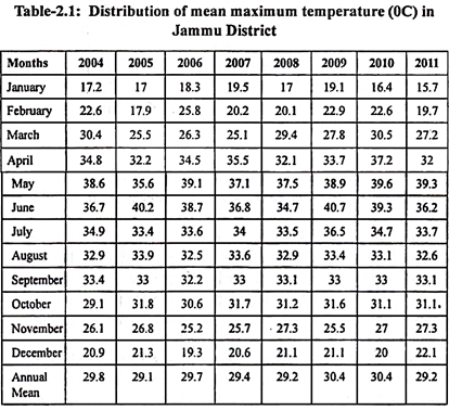
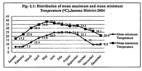
The figure 2.1 reveals the distribution of mean maximum and mean minimum Temperature in Degree Celsius in Jammu District (2004). The graph shows that the highest mean maximum Temperature is found in the month of May i.e. 38.6°C and the lowest mean minimum Temperature is found in the month of January i.e. 6.6°C.
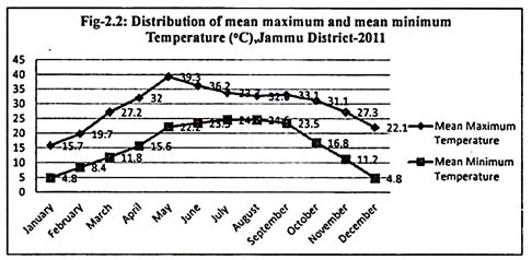
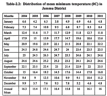
The figure 2.2 reveals the distribution of mean maximum and mean minimum Temperature in Degree Celsius in Jammu District (2011). The graph shows that the highest mean maximum Temperature is found in the month of May i.e. 39.3°C and the lowest mean minimum Temperature is found in the month of January and December i.e. 4.8°C.
Essay # 8. Flora and Fauna of Jammu District:
The forests of Jammu district represent typical subtropical vegetation. The lower altitudinal zonation is dominated by shrubs which occupy considerable area of this division. In the zone, broad leaved trees are also found mostly scattered and sometimes in patches. As we go higher towards the outer reaches of the ridges, these scrubs are found to be mixed with scattered trees of Chir.
As we go further higher, pure Chir patches are found. The shrubs found in lower part of the district are mostly dense. The main shrubs found in the region are Carissa Spinaium, Dodonea Viscosa, Adhatoda Vasica, Colebrookia Oppositifolia etc. Other shrubs that are found are Euphorbia Royleana, Nerium Odorum, Wood Fordia Floriunda, Wood Fordia Fruiticosa, Wendlandia Exsertia, Marraya Koenigii, Parthenium Hystrophorus, Zanthium Straumarium, Lantana Camara and Opomaea Fistula. These shrubs are mostly mixed with scattered broad leaved trees.
The main broad leaved species that are found in the district are Acacia Arabica, Acacia Modesta, Albizzia Lebbek, Butea Monosperma, Cassia Fistula, Dalbergia Sissoo, Emblica Officinals, Mangifera Indica, Lennea Coromendalica, Mallotus Phillipinesis, Olea Causpidate, Punica Granatum, Bombax Cebia, Syzgium Cumini, Zizyphus Jujube and Ficus species. Chir start appearing in the middle altitudinal zonation mixed with shrubs and broad leaved species and proceeds to dominate the vegetation towards the upper zone. It is also found in depression along the nallas mixed with broad leaved species especially in Kalidhar range.
The district in the past contained few game reserves popularly known as “Rakhs” offering a variety of fauna in the tract. These “Rakhs” being restricted areas, provided adequate protection and suitable habitat for wild animals of the areas. However, due to increasing human and livestock pressure over a period of time, the natural habitat of wild animals shrank rapidly with the result that the number of wild animals and their variety depleted considerably.
Jammu forest division has three wild life sanctuaries namely Nandani wild life sanctuary, Ramnagar and Mansar-Surinsar wild life sanctuary and two deer parks, one at Manda, Jammu and another at Mansar besides few wetlands reserves.
The management of these sanctuaries, deer parks and wetland reserves lied completely with the Wildlife Protection Department.
Some of the important wildlife species found in the region are as under:
Mammals:
Leopard (Panthera Pardus), Jackal (Canis Aurcus), Jungle cat (Felis Chaus), Indian Fox (Vulpes Bengalensis), Himalayan Black Bear (Selenaractos Thibetanus).
Rodents:
Five Striped Palm Squirrel (Funambulus Penanti), Indian Porcupine (Hystrix Indica), Common Indian Hare (Lepus Negricolis), Indian Field Mouse (Mus Boodnga).
Goat Group:
Grey Himalayan Goral (Nemorhaedus Goral).
Deer Group:
Barking Deer (Munticacus Muntjak), Hog Deer (Asiporcinas).
Pigs:
Indian Wild Boar (Sus Scrofa).
Primates:
Indian Langur (Presbytes Entellus), Monkey (Macaca Mulatta).
Pheasants and Fowl Group:
Red Jungle Fowl (Gallus), Common Pea Fowl (Pavo Cristatus).