
Here is an essay on the ‘Earth’ for class 6, 7, 8, 9, 10, 11 and 12. Find paragraphs, long and short essays on the ‘Earth’ especially written for school and college students.
Essay on the Earth
Essay Contents:
- Essay on Origin of the Earth
- Essay on Evolution of the Earth
- Essay on Size and Shape of the Earth
- Essay on Structure of the Earth
- Essay on Motion of the Earth
- Essay on Latitudinal and Longitudinal Measurements of the Earth
- Essay on Heat Zones of the Earth
- Essay on Compositional Layering of the Earth’s Interior
- Essay on Position of the Earth
Essay # 1. Origin of the Earth:
The earth is believed to be formed from a small part of the sun and most of the theories concerned with the origin of the earth emphasize that the planet originated as a hot gaseous mass which upon cooling, turned first into liquid and then solid. An early theory was put forth by Kant, which is popularly known as the gaseous hypothesis.
A more popular theory was advanced by Laplace which is called the nebular hypothesis. This theory considers earth being formed through the solidification of the mass of a ring thrown away by a cooling and rotating nebula (sun) and this ring was one of the nine such rings which formed various planets.
A more plausible theory put forth by Jeans and Jeffreys assumes origin of the earth on the basis of the presence of two nebulae. This theory is called the tidal hypothesis and it belongs to the group of the binary star theories. According to this theory, a large nebula wandering in the space came very close to another smaller nebula which is sun and its gravitational pull caused a huge tidal upsurge of matter on the surface of the smaller nebula.
As the larger nebula moved away from the smaller one in its journey, the matter rising as a tidal wave from the surface of the smaller nebula was pulled towards it and was drawn to a distance from which it could not come back to the parent body. However, it could not follow the large nebula also and as the larger nebula went away the rising tongue of matter was detached from the smaller nebula.
On cooling, this matter condensed to form the planets, including the earth, and the planets thus formed started revolving around the sun. This hypothesis is considered to be highly probable and close to reality. The cigar-shaped arrangement of the planets going away from the sun, with the smallest planets located closest and farthest from the sun and the larger ones occupying intermediate positions, strengthens this view.
The above theory considers that the earth originated as a hot mass and cooled slowly to develop a solid crust and the inner part of the earth from which the heat loss has been slow is still liquid. Some of the other theories also assume that the earth originated as a mass of solid matter and it is the decay of the radioactive elements in its interior and the pressure of the overlying strata due to which the interior of the earth is in liquid state.
In whatever state the earth might have come into existence, the aggregation of the mass has led to a differentiation of the matter forming it on the basis of the density. The denser matter forms the central part of the earth and the surface rocks are made up of the lighter materials.
The rocks forming the surface layer of the earth which are rich in lighter minerals such as aluminium are called sial (silica and aluminium) while the denser rocks forming the inner layers of the earth are called sima (silica and magnesium) and nife (nickel and iron).
This differentiation of various elements of the earth has been responsible for the layered structure of the earth. The formation of the solid crust of the earth took place sometimes 4.6 billion years ago and it is taken as the beginning of the history of the earth as such.
Modern Theories:
The most popular theory of our universe’s origin centres on a cosmic cataclysm unmatched in history—the big bang. This theory was born out of observation that other galaxies are moving away from our own at great speed, in all directions, as if they all had been propelled by an ancient explosive force.
Before the big bang, scientists believe, that the entire vastness of the universe, including all of its matter and radiations, was compressed into a hot, dense mass just a few millimetres across. This nearly incomprehensible state is theorized to have existed for just a fraction of the first second of time.
Big bang proponents suggest that some 10-20 billion years ago, a massive blast allowed all the universe’s known matter and energy—even space and time themselves—to spring from some ancient and unknown type of energy.
The theory maintains that, in the instant—a trillion-trillionth of a second—after the big bang, the universe expanded with incomprehensible speed from its pebble-size origin to astronomical scope. Expansion has apparently continued, but much more slowly, over the ensuing billions of years.
Scientists can’t be sure exactly how the universe evolved after the big bang. Many believe that as time passed and matter cooled, more diverse kinds of atoms began to form, and they eventually condensed into the stars and galaxies of our existing universe.
Big Bang Theory:
The Big Bang theory considers the following stages in the development of the universe:
(i) In the beginning, all matter forming the universe existed at one place in the form of a ‘tiny ball’ (singular atom) with an unimaginably small volume, infinite temperature and infinite density.
(ii) At the ‘Big Bang’, the tiny ball exploded violently. This led to a huge expansion. It is now generally accepted that the event of big bang took place 13.7 billion years ago. The expansion is continued even today.
As it grew, some energy was converted into matter. There was particularly rapid expansion within fractions of a second after the bang. Thereafter, the expansion has slowed down. Within first three minutes of the Big Bang event, the first atom began to form.
(iii) Within 300,000 years from the Big Bang, temperature dropped to 4,500 K (Kelvin) and gave rise to atomic matter. The universe became transparent.
Origin of the Theory:
A Belgian priest named Georges Lemaitre first suggested the big bang theory in the 1920s when he theorized that the universe began from a single primordial atom. The idea subsequently received major boosts by Edwin Hubble’s observations that galaxies are speeding away from us in all directions, and from the discovery of cosmic microwave radiation by Arno Penzias and Robert Wilson.
The glow of cosmic microwave background radiation, which is found throughout the universe, is thought to be a tangible remnant of leftover light from the big bang. The radiation akin to that is used to transmit TV signals via antennas. But it is the oldest known radiation and may hold many secrets about the universe’s earliest moments.
The big bang theory leaves several major questions unanswered. One is the original cause of the big bang itself. Several answers have been proposed to address this fundamental question, but none has been proven—and even adequately testing them has proved to be a formidable challenge.
Essay # 2. Evolution of the Earth:
The earth has a layered structure. From the outermost end of the atmosphere to the centre of the earth, the material that exists is not uniform. The atmospheric matter has the least density. From the surface to deeper depths, the earth’s interior has different zones and each of these contains materials with different characteristics.
Evolution of Atmosphere and Hydrosphere:
The present composition of earth’s atmosphere is chiefly contributed by nitrogen and oxygen. There are three stages in the evolution of the present atmosphere. The first stage is marked by the loss of primordial atmosphere. In the second stage, the hot interior of the earth contributed to the evolution of the atmosphere. Finally, the composition of the atmosphere was modified by the living world through the process of photosynthesis.
The early atmosphere, with hydrogen and helium, is supposed to have been stripped off as a result of the solar winds. This happened not only in case of the earth, but also in all the terrestrial planets, which were supposed to have lost their primordial atmosphere through the impact of solar winds. During the cooling of the earth, gases and water vapour were released from the interior solid earth.
This started the evolution of the present atmosphere. The early atmosphere largely contained water vapour, nitrogen, carbon dioxide, methane, ammonia and very little of free oxygen. The process through which the gases were outpoured from the interior is called degassing. Continuous volcanic eruptions contributed water vapour and gases to the atmosphere.
As the earth cooled, the water vapour released started getting condensed. The carbon dioxide in the atmosphere got dissolved in rainwater and the temperature further decreased causing more condensation and more rains. The rainwater falling onto the surface got collected in the depressions to give rise to oceans.
The earth’s oceans were formed within 500 million years from the formation of the earth. This tells us that the oceans are as old as 4,000 million years. Sometime around 3,800 million years ago, life began to evolve. However, around 2,500-3,000 million years ago, the process of photosynthesis got evolved. Life was confined to the oceans for a long time.
Oceans began to have the contribution of oxygen through the process of photosynthesis. Eventually, oceans were saturated with oxygen, and 2,000 million years ago, oxygen began to flood the atmosphere.
Essay # 3. Size and Shape of the Earth:
Earth, with an average distance of 92,955,820 miles (149,597,890 km) from the sun, is the third planet and one of the most unique planets in the solar system. It was formed around 4.5-4.6 billion years ago and is the only planet known to sustain life. This is because factors like its atmospheric composition and physical properties such as the presence of water, over 70.8% of the planet allows life to thrive.
Earth is also unique however, because it is the largest of the terrestrial planets (one that is composed of a thin layer of rocks as opposed to those that are mostly made up of gases like Jupiter or Saturn) based on its mass, density, and diameter. Earth is also the fifth largest planet in the entire solar system.
Earth’s circumference and diameter differ because its shape is classified as an oblate spheroid or ellipsoid, instead of a true sphere. This means that instead of being of equal circumference in all areas, the poles are squished, resulting in a bulge at the equator, and thus a larger circumference and diameter there.
The equatorial bulge at Earth’s equator is measured at 26.5 miles (42.72 km) and is caused by the planet’s rotation and gravity. Gravity itself causes planets and other celestial bodies to contract and form a sphere. This is because it pulls all the mass of an object as close to the centre of gravity (the Earth’s core in this case) as possible.
Because Earth rotates, this sphere is distorted by the centrifugal force. This is the force that causes objects to move outward away from the centre of gravity. Therefore, as the Earth rotates, centrifugal force is greatest at the equator so it causes a slight outward bulge there, giving that region a larger circumference and diameter.
Essay # 4. Structure of Earth:
i. It is almost round in shape and has a diameter of 1.27 x 10⁴ km.
ii. Its real shape is a sphere flattened at the poles and buldged in the plane normal to the poles.
iii. The earth’s inner core is a solid mass made of iron and nickel and the next outer core is melted state of iron and nickel. The outermost portion is made of rocks.
iv. The existence of blue green algae indicates beginning of photosynthesis at least 3 x 10⁹ years ago. As a result of photosynthesis, the level of O2 and O3 is increased in the atmosphere which block the ultra violet (UV) solar radiation coming from the ‘sun’. Half the earth is lit by the sunlight at a time. It reflects one-third of the sunlight that falls on it, is known as earth’s albedo.
v. The length of days and nights keep changing because the earth is spinning about its axis which is inclined at an angle of 23.5°.
Essay # 5. Motions of the Earth:
The earth has two types of motions, namely rotation and revolution:
i. Rotation:
The Earth rotates on its axis, from west to east like a top. This motion is called Rotation of the Earth.
ii. Revolution:
While rotating on its axis, the earth also goes around the sun in an elliptical path and completes one round in 365 days and 6 hours. The elliptical path traced by the earth is called its orbit. This motion of the earth is called revolution.
Essay # 6. Latitudinal and Longitudinal Measurements of the Earth:
A key geographical question throughout the human experience has been, ‘Where am I?’ In classical Greece and China, attempts were made to create logical grid systems of the world to answer this question. The ancient Greek geographer Ptolemy created a grid system and listed the coordinates for places throughout the known world in his book Geography. But it wasn’t until the middle ages that the latitude and longitude system was developed and implemented. This system is written in degrees, using the symbol.
i. Latitude:
Latitude is the angular distance of any point on Earth measured north or south of the equator in degrees, minutes and seconds.
The equator is a line going around Earth and is halfway between the North and South Poles, it is given a latitude of 0°. Values increasing north of the equator and are considered positive and values decrease towards south of the equator and are sometimes considered negative or have south attached to them.
For example, if a latitude of 30°N was given, this would mean that it was north of the equator. The latitude -30° or 30°S is a location south of the equator. On a map, these are the lines running horizontally from east-west.
Latitude lines are also sometimes called parallels because they are parallel and equidistant from each other. Each degree of latitude is about 69 miles (111 km) apart. The degree measure of latitude is the name of the angle from the equator.
While the parallel names the actual line along which degree points are measured. For example, 45 °N latitude is the angle of latitude between the equator and the 45th parallel (it is also halfway between the equator and the North Pole). The 45th parallel is the line along which all latitudinal values are 45°. The line is also parallel to the 46th and 44th parallels.
Like the equator, parallels are also considered circles of latitude or lines that circle the entire Earth. Since the equator divides the Earth into two equal halves and its centre coincides with that of the Earth, it is the only line of latitude that is a great circle while all other parallels are small circles.
Importance of Latitude:
Besides making it easier for one to locate different places on Earth, latitude is important to geography because it helps navigation and researchers understand the various patterns seen on Earth. High latitudes for example, have very different climates than low latitudes. In the Arctic it is much colder and drier than in the tropics. This is a direct result of the unequal distribution of solar insolation between the equator and the rest of the Earth.
Increasingly, latitude also results in extreme seasonal differences in climate because sunlight and sun angle vary at different times of the year depending on latitude. This affects temperature and the types of flora and fauna that can live in an area. Tropical rainforests for example, are the most biodiverse places in the world, while harsh conditions in the Arctic and Antarctic make it difficult for many species to survive.
Development of Latitudinal Measurements:
Since ancient times, people have tried to come up with reliable systems with which to measure their location on Earth. For centuries, both Greek and Chinese scientists attempted several different methods but a reliable one did not develop until the ancient Greek geographer, astronomer and mathematician, Ptolemy, created a grid system for the Earth. To do this, he divided a circle into 360°. Each degree comprised 60 minutes (60′) and each minute comprised 60 seconds (60″). He then applied this method to Earth’s surface and located places with degrees, minutes and seconds and published the coordinates in his book Geography.
Although this was the best attempt at defining the location of places on Earth at the time, the precise length of a degree of latitude was unresolved for around 17 centuries. In the middle ages, the system was finally fully developed and implemented with a degree being 69 miles (111 km) and with coordinates being written in degrees with the symbol Minutes and seconds are written with ‘, and “, respectively.
Important Lines of Latitude:
When studying latitude, there are three significant lines to remember. The first of these is the equator. The equator, located at 0°, is the longest line of latitude on Earth at 24,901.55 miles (40,075.16 km). It is significant because it is the exact centre of the Earth and it divides the Earth into the Northern and Southern Hemispheres. It also receives the direct sunlight on the two equinoxes.
At 23.5°N is the Tropic of Cancer. It runs through Mexico, Egypt, Saudi Arabia, India and Southern China. The Tropic of Capricorn is at 23.5°S and it runs through Chile, Southern Brazil, South Africa and Australia. These two parallels are significant because they receive direct sun on the two solstices. In addition, the area between the two lines is the area known as the tropics. This region does not experience seasons and the climate is normally warm and wet.
Finally, the Arctic Circle and Antarctic Circle are also important lines of latitude. They are at 66°32’N and 66°32’S. The climate of these locations is harsh and Antarctica is the largest desert in the world. These are also places that experience 24-hours sunlight and 24-hour darkness in the world.
Measuring Latitude:
Today, latitude is still measured in degrees, minutes and seconds. A degree of latitude is still around 69 miles (111 km) while a minute is approximately 1.15 miles (1.85 km). A second of latitude is just over 100 feet (30 m). Paris, France for example, has a coordinate of 48°51’24″N. The 48° indicates that it lies near the 48th parallel while the minutes and seconds indicate just how close it is to that line. The N shows that it is north of the equator.
In addition to degrees, minutes and seconds, latitude can also be measured using decimal degrees. Paris’ location in this format looks like, 48.856°. Both formats are correct, although degrees, minutes and seconds is the most common format for latitude. Both however can be converted into the other and allow people to locate places on Earth within inches.
One nautical mile, a mile type used by sailors and navigators in the shipping and aviation industries, represents one minute of latitude. Parallels of latitude are approximately 60 nautical (nm) apart.
Finally, areas described as having low latitude are those with lower coordinates or are closer to the equator while those with high latitudes have high coordinates and are far. For example, the Arctic Circle, which has a high latitude is at 66°32’N.
ii. Longitude:
Longitude is the angular distance of any point on Earth measured east or west of a point on Earth’s surface.
Unlike latitude there is no easy point of reference such as the equator to be designated as zero degrees in the longitude system. To avoid confusion, the world’s nations have agreed that the Prime Meridian, which passes through the Royal Observatory in Greenwich, England, will serve as that reference point and be designated as zero degrees.
Because of this designation, longitude is measured in degrees west or east of the Prime Meridian. For example, 30°E, the line passing through eastern Africa, is an angular distance of 30° east of the Prime Meridian. 30°W, which is in the middle of the Atlantic Ocean, is an angular distance of 30° west of the Prime Meridian.
There are 180 degrees east of the Prime Meridian and coordinates are sometimes given without the designation of ‘E’ or east. When this is used, a positive value represents coordinates east of the Prime Meridian.
There are also 180 degrees west of the Prime Meridian and when ‘W’ or west is omitted in a coordinate a negative value such as -30° represents coordinates west of the Prime Meridian. The 180° line is neither east nor west and approximates the International Date Line.
On a map, lines of longitude are the vertical lines running from the North Pole to the South Pole and are perpendicular to the lines of latitude. Every line of longitude also crosses the equator. Because longitude lines are not parallel, they are known as meridians. Like parallels, meridians name the specific line and indicate the distance east or west of a 0° line. Meridians converge at the poles and are farthest apart at the equator [about 69 miles (111 km) apart].
Development and History of Longitude:
For centuries, mariners and explorers worked to determine their longitude in an effort to make navigation easier. Latitude was determined easily by observing the inclination of the sun or the position of known stars in the sky and calculating the angular distance from the horizon to them. Longitude could not be determined in this way because Earth’s rotation constantly changes the position of stars and the sun.
The first person to offer a method for measuring longitude was the explorer Amerigo Vespucci. In the late 1400s, he started measuring and comparing the positions of the moon and Mars with their predicted positions over several nights at the same time. In his measurements, Vespucci calculated the angle between his location, the moon and Mars.
By doing this, Vespucci got a rough estimate of longitude. This method did not become widely used, however because it relied on a specific astronomical event. Observers also needed to know the specific time and measure the moon and Mars’ positions on a stable viewing platform—both of which were difficult to do at sea.
In the early 1600s, a new idea to measure longitude was developed when Galileo determined that it could be measured with two clocks. He said that any point on Earth took 24 hours to travel the full 360° rotation of Earth. He found that if you divide 360° by 24 hours, you find that a point on Earth travels 15° of longitude every hour.
Therefore, with an accurate clock at sea, a comparison of two clocks would determine longitude. One clock would be at the home port and the other on the ship. The clock on the ship would need to be reset to local noon each day. The time difference would then indicate the longitudinal difference travelled as one hour represented a 15° change in longitude.
Shortly thereafter, there were several attempts to make a clock that could accurately tell time on the unstable deck of a ship. In 1728, clockmaker John Harrison began working on the problem and in 1760, he produced the first marine chronometer called Number 4. In 1761, the chronometer was tested and determined to be accurate, officially making it possible to measure longitude on land and at sea.
Measuring Longitude:
Today, longitude is more accurately measured with atomic clocks and satellites. The Earth is still divided equally into 360° of longitude with 180° being east of the Prime Meridian and 180° west. Longitudinal coordinates are divided into degrees, minutes and seconds with 60 minutes making up a degree and 60 seconds comprising a minute.
For example, Beijing, China’s longitude is 116°23’30″E. The 116° indicates that it lies near the 116th meridian while the minutes and seconds indicate just how close it is to that line. The ‘E’ indicates that it is that distance east of the Prime Meridian. Although less common, longitude can also be written in decimal degrees.
In addition to the Prime Meridian, which is the 0° mark in today’s longitudinal system, the International Date Line is also an important marker. It is the 180° meridian on the opposite side of the Earth and is where the eastern and western hemispheres meet.
It also marks the place where each day officially begins. At the International Date Line, the west side of the line is always one day ahead of the east side, no matter what time of the day it is when the line is crossed. This is because the Earth rotates east on its axis.
Standard Time:
Standard time is the result of synchronizing clocks in different geographical locations within a time zone to the same time, rather than using the local meridian as in local mean time or solar time. Historically, this helped in the process of weather forecasting and train travel.
The concept became established in the late 19th century. The time so set has come to be defined in terms of offsets from Universal time. Where daylight saving time is used as the term standard time typically refers to the time without the offset for daylight saving time.
The adoption of Standard Time, because of the inseparable correspondence between time and longitude, solidified the concepts of dividing the globe half into an eastern and western hemisphere, with one Prime Meridian (as well as its opposite International Date Line) replacing the various Prime Meridians that were in use.
International Date Line:
The International Date Line sits on the 180° line of longitude in the middle of the Pacific Ocean, and is the imaginary line that separates two consecutive calendar days. It is not a perfectly straight line and has been moved slightly over the years to accommodate needs (or requests) of varied countries in the Pacific Ocean.
Note how it bends to include all of Kiribati, Samoa, Tonga and Tokelau in the Eastern Hemisphere. Immediately to the left of the International Date Line the date is always one day ahead of the date (or day) immediately to the right of the International Date Line in the Western Hemisphere.
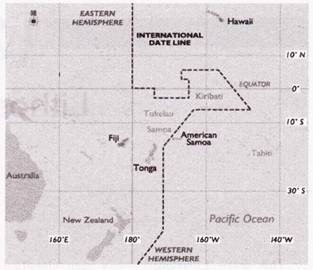
As you travel further west, note that the time in Fiji is one hour earlier than Tonga. You will also notice that Hawaii, further to the east of American Samoa, is one hour later in time. So, travel east across the International Date Line results in a day, or 24 hours, being subtracted. Travel west across the International Date Line results in a day being added.
Essay # 7. Heat Zones of the Earth:
The mid-day sun is exactly overhead at least once a year on all latitudes in between the Tropic of Cancer and the Tropic of Capricorn. This area, therefore, receives the maximum heat and is called the Torrid Zone. The midday sun never shines overhead on any latitude beyond the Tropic of Cancer and the Tropic of Capricorn.
The angle of the sun’s rays goes on decreasing towards the poles. As such, the areas bounded by the Tropic of Cancer and the Arctic Circle in the Northern Hemisphere, and the Tropic of Capricorn and the Antarctic Circle in the Southern Hemisphere, have moderate temperatures.
These are, therefore, called Temperate Zones. Areas lying between the Arctic Circle and the North Pole in the Northern Hemisphere and the Antarctic Circle and the South Pole in the Southern Hemisphere, are very cold. It is because here the sun does not rise much above the horizon. Therefore, its rays are always slanting. These are, therefore, called Frigid Zones.
Essay # 8. Compositional Layering of the Earth’s Interior:
The earth has a concentrically layered structure (Fig. 2.1).
i. The Core:
The innermost part of the earth is the core. The volume of the core is 16 per cent of the earth’s volume. The mass of the core is about one third of the mass of the earth. The core consists of material denser than the rest of the earth. The core being denser than the rest of the earth must have sunk inwards during the formation of the earth.
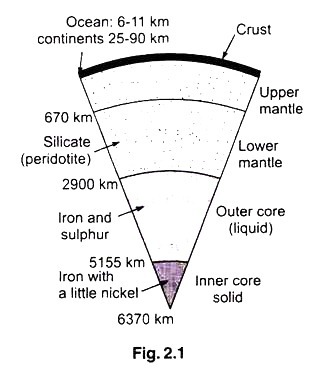
The core consists of two distinct parts viz. the inner core and the outer core. The inner core consists of mainly iron mixed with a little quantity of nickel. Though the temperature of the inner core is about 4700° C, it is in solid form because of the immense pressure.
The surrounding outer core has a lower density. It may consist of mostly iron with about 10 per cent of a lighter element which may be one or more of the elements, oxygen, sulphur, carbon, hydrogen and potassium. Though the exact chemical composition of the outer core is uncertain, we are sure it is in liquid form.
Even though the molten iron content of the outer core has a surprisingly low viscosity (slightly more than that of water) it has very high density and is therefore too dense to move up to the surface. The molten material is in rapid circulation and is a good conductor of electricity.
ii. The Mantle:
The mantle surrounds the core. The density of the mantle near its base is about two-thirds of the density of the outer core. The mantle consists of rocky material with a mass equal to two-thirds of the earth’s mass. Silicon and oxygen are the most abundant elements and hence the most common minerals here are compounds of silicon and oxygen along with a few other elements.
These minerals are described as silicates. The mantle consists of about 45 per cent silica. Its composition is very much like that of a rock, peridotite. Other elements here are magnesium and iron. Hence the common minerals of the mantle are silicates containing magnesium and iron, combined with silicon and oxygen.
The mantle is divided into the upper and lower mantle represented by seismic and chemical changes in the layer. The upper mantle falls between 20 km and 70 km beneath the continental crust and about 5 km beneath the oceanic crust. It begins to transition to the lower mantle at about 410 km deep past the transition zone. The lower mantle starts about 670 km to about 2885 km deep.
iii. The Crust:
The curst is the uppermost layer overlying the mantle. The crust is relatively a thin layer amounting to less than 0.5 per cent of the earth’s mass. The curst contains larger percentage of silicon and other element. The varieties of silicate minerals commonly present in the crust differ from those present in the mantle.
The crust has two distinct zones namely oceanic and continental. The oceanic crust is about 5 to 10 km. thick mainly basaltic in composition forming the floor of the deep oceans. The continental crust makes up the continents and the floor of the shallow seas close to the major land masses. This may be as thin as 25 km but may be as much as 90 km thick under the highest mountain ranges.
It consists mainly of igneous rocks very rich in silica (with richer silica than in the oceanic crust). It also contains some rocks not formed by igneous processes.
Some of the rocks are sedimentary rocks formed from accumulation of fragments produced by chemical as well as decay of rock exposed at the surface for a very long time. The other rocks are metamorphic rocks formed from the original igneous rocks or the sedimentary rocks which have recrystallized by the action of extreme heat and pressure.
Studying the internal structure of the earth has its importance, due to its many influences on our planet’s past, present and future geology. For instance, the mantle and crust are directly involved in plate tectonics or how our planet’s land masses move around the planet.
Convection in the Earth’s mantle generates and recycles the planet’s crust at the plate boundaries over time. And the inner and the outer cores appear to be directly related to the generation of the Earth’s magnetic field.
Mohorovicic Discontinuity is the boundary between the crust and the mantle and was proposed by the Croatian geologist Andrija Mohorovicic. In 1909 he analyzed data from a Croatian earthquake, calculating a jump in seismic wave velocity at a depth of about 54 km. This turned out to be the mantle boundary underneath under the continental crust, a division now called the Moho or Mohorovicic discontinuity.
Geologists believe that the change is compositional the type of rock changing from the crust (with a seismic velocity of 6 km per second) to the denser mantle (with a seismic velocity of 8 km per second).
Like most interior layers, the Moho varies in depth. Beneath the continents, the Moho averages around 35 km but, overall it ranges from around 20 km to 70 or 90 km in depth. Beneath the oceans, the Moho averages about 7 km below the ocean floor.
Magma and Lava:
Molten rock present under the earth surface, with some dissolved gases and some floating material is called magma. Rock bodies can melt only in places where a large amount of heat is concentrated and the pressure is reduced. The molten magma is often at a high temperature, like 1000°C. Such high temperatures enough to cause melting of rocks exist at depths 70 km to 200 km below the earth’s surface.
Magma is less dense than solid rock surrounding it and hence it is buoyant and it tends to rise to reach the earth’s surface. When the molten rock erupts out of the earth’s surface it is called Lava.
While it is not possible to make a study of magma directly, the lava has been studied and the following observations have been made:
(i) Magma has a range of composition with silica (SiO2) as the dominant constituent.
(ii) It is characterized by very high temperature.
(iii) It has the property of a liquid and has the ability to flow.
The chemical composition of magma is dominated by the most abundant elements Silicon (Si), Aluminium (Al). Iron (Fe), Calcium (Ca), Magnesium (Mg). Sodium (Na). Potassium (K), Hydrogen (H) and Oxygen (O).
Oxygen being the most abundant anion, the composition of the magma can be expressed in terms oxides like SiO2, Al2O3, CaO and H2O. Silicon being the most abundant component of the common magmas, Silicon dioxide accounts for 50 to 75 per cent of magma by weight. Such magma with silica as the dominant component are called Silicate magmas.
There are three most common types of Silicate magma, namely basaltic magma (45 to 50% SiO2), Andesitic magma (about 60% SiO2) and Rhyolitic magma (70 to 75% SiO2). Basaltic magma is the most common among the above types of magma. Most magmas also contain 0.2% to 3% (by weight) of dissolved gases like carbon dioxide and water vapour. These dissolved gases, though present in small quantity influence the properties of magmas.
It may be noted that the continental crust and the oceanic crust do not have the same composition. Granitic magma form continental crust at depths of 30 to 60 km. Ocean crust is basaltic whose minerals have very high melting temperature.
The basaltic magmas form at depths of 100 to 350 km. Both these types of rock also contain some minerals which melt at lower temperatures. Accordingly the magma forms as a slush of hot viscous liquid enclosing the still solid crystals. The magma in such a state is said to be in a zone of partial melt.
As melting is complete, the magma body begins to rise, being less dense than the surrounding rock. It moves through fissures and cracks and widens them. As the magma rises, its pressure decreases allowing more minerals to remain in the molten state at lower temperatures.
As the magma reaches close to the surface, it melts the surrounding rock creating underground magma pools called magma chambers. From the magma chambers, the molten magma may flow out to the surface as lava or can get solidified to become an intrusive rock below the earth’s surface.
Basaltic magma is more fluid than granitic magma. Hence the basaltic magma rises faster and due to its decreasing pressure its melting temperature falls faster and this magma finds its way out of the surface to become lava. On the contrary granitic magma being more viscous has a lower rate of ascent and cools and solidifies before reaching the surface.
Essay # 9. Positions of the Earth:
The earth moves not only on its axis but also in its orbit around the sun. Therefore, the earth changes its position continuously with respect to the sun. There are four major positions of the earth, while it revolves around the sun.
(i) Position on 21st June:
In this position the sun shines perpendicularly over the Tropic of Cancer. This position in called the Summer Solstice. It is the time of summer season in the northern hemisphere, while in the southern hemisphere, it is winter season. The day in the northern hemisphere is longest on 21st June.
(ii) Position on 22nd December:
In this position the Sun shines perpendicularly over the Tropic of Capricorn. This position is called Winter Solstice. During this period, days are long and nights are short in the southern hemisphere. This position marks the summers in the southern hemisphere and winters in the northern hemisphere.
(iii) Positions on 21st March and 23rd September:
In these two positions the Sun shines directly overhead on the Equator. Therefore, half part of all latitudes receives the sun-light at these times. Hence, everywhere, the duration of day and night is equal. Seasons are also similar in both the hemispheres. These two positions are referred to as Equinoxes. 21st March is called Spring or Vernal Equinox whereas 23rd September is called Autumn Equinox.